IMAGES TAKEN NEAR TO
Adeline Street, CARDIFF, CF24 2BH
Introduction
This page details the photographs taken nearby to Adeline Street, CF24 2BH by members of the Geograph project.
The Geograph project started in 2005 with the aim of publishing, organising and preserving representative images for every square kilometre of Great Britain, Ireland and the Isle of Man.

There are currently over 7.5m images from over14,400 individuals and you can help contribute to the project by visiting https://www.geograph.org.uk
Image Map
Images are licensed for reuse under creativecommons.org/licenses/by-sa/2.0
Notes
- Clicking on the map will re-center to the selected point.
- The higher the marker number, the further away the image location is from the centre of the postcode.
Image Listing (78 Images Found)
Images are licensed for reuse under creativecommons.org/licenses/by-sa/2.0
Image
Details
Distance
1
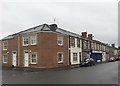
36 Carlisle Street
At the end of a row of pre-war houses, modernised flats now occupy the site of Ollin & Whitehurst, Greengrocers, in Carlisle Street, Splott.
Image: © Alan Hughes
Taken: 23 Dec 2016
0.04 miles
2

Baptist Court, Splott, Cardiff
Located on the corner of Splott Road and Railway Street.
Built in 1985, Baptist Court contains 24 1- or 2-bedroom rented-tenure flats. The building is managed by Aelwyd Housing Association.
Image: © Jaggery
Taken: 3 Sep 2010
0.07 miles
3
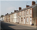
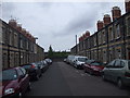
Janet Street, Cardiff
Houses on the north side of the street, viewed from the Carlisle Street end.
Image: © Jaggery
Taken: 3 Sep 2010
0.07 miles
4
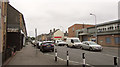
Splott Road
On the right is a recreation, community centre and library.
Image: © Derek Harper
Taken: 16 Jun 2018
0.08 miles
5
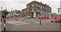
Pedestrian crossing, Splott
At the junction of Splott Road with Railway Street.
Image: © Derek Harper
Taken: 16 Jun 2018
0.09 miles
6
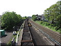
Track replacement near Cardiff
An engineers' possession over the bank holiday weekend sees the relief lines being replaced east of Cardiff.
Image: © Gareth James
Taken: 3 May 2014
0.10 miles
7
Refurbished terraced houses, Zinc St, Cardiff
The wall at the end of the street is the railway boundary wall.
Image: © John Lord
Taken: 8 May 2010
0.10 miles
8
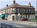
NatWest, Splott, Cardiff
Bank branch located at 41 Splott Road, on the corner of Carlisle Street.
Image: © Jaggery
Taken: 3 Sep 2010
0.10 miles
9
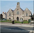
St Saviour's Church, Cardiff
Church in Wales church, viewed across Splott Road. The church was built in 1888.
Image: © Jaggery
Taken: 3 Sep 2010
0.10 miles
10
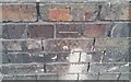
Ordnance Survey Cut Mark
This OS cut mark can be found on the SW parapet of the railway bridge. It marks a point 13.969m above mean sea level.
Image: © Adrian Dust
Taken: 12 Oct 2017
0.10 miles