IMAGES TAKEN NEAR TO
Felsted Close, CARDIFF, CF23 8LR
Introduction
This page details the photographs taken nearby to Felsted Close, CF23 8LR by members of the Geograph project.
The Geograph project started in 2005 with the aim of publishing, organising and preserving representative images for every square kilometre of Great Britain, Ireland and the Isle of Man.

There are currently over 7.5m images from over14,400 individuals and you can help contribute to the project by visiting https://www.geograph.org.uk
Image Map
Images are licensed for reuse under creativecommons.org/licenses/by-sa/2.0
Notes
- Clicking on the map will re-center to the selected point.
- The higher the marker number, the further away the image location is from the centre of the postcode.
Image Listing (22 Images Found)
Images are licensed for reuse under creativecommons.org/licenses/by-sa/2.0
Image
Details
Distance
1
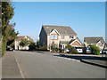
Naseby Close, Pontprennau, Cardiff
Houses on the corner of Naseby Close and Croescadarn Road.
Image: © Jaggery
Taken: 11 Oct 2010
0.06 miles
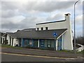
2
Pontprennau Community Church Centre, Cardiff
Located on Heol Pontprennau. Pontprennau Community Church Centre was dedicated in June 2003.
It is home to the ecumenical worshipping community and offers a range of modern facilities open for use by the wider community. On the other side of the building is their coffee shop. http://www.geograph.org.uk/photo/2112289
Image: © Jaggery
Taken: 11 Oct 2010
0.13 miles
3
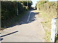
Pontprennau : Path and cycleway to St Mellons Road
On the west side of Pontprennau Community Centre, http://www.geograph.org.uk/photo/2112298 a cycleway and path head away from Heol Pontprennau towards St Mellons Road.
Image: © Jaggery
Taken: 11 Oct 2010
0.14 miles
4
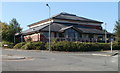
Pontprennau Community Centre
Located on Heol Pontprennau, opposite the Church Centre. http://www.geograph.org.uk/photo/2112276 Facilities include an indoor sports hall, two badminton courts and a community room.
Image: © Jaggery
Taken: 11 Oct 2010
0.14 miles
5
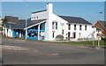
Coffee shop, Pontprennau Community Church Centre
The small blue building is PC's Coffee Shop, a part of Pontprennau Community Church Centre, which opened in 2003. http://www.geograph.org.uk/photo/2112276 to a view of the centre from another viewpoint.
Image: © Jaggery
Taken: 11 Oct 2010
0.14 miles
6
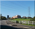
Power lines cross Heol Pontprennau, Cardiff
The view NW from Heol Pontprennau across a narrow strip of open ground, the northern edge of which abuts St Mellons Road (B4562).
Image: © Jaggery
Taken: 11 Oct 2010
0.14 miles
7
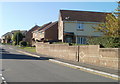
Almond Road, Cardiff
On the west side of Croescadarn Road, Almond Road leads to six other residential roads. This view is of the north side of the road, from near the corner of Croescadarn Road.
Image: © Jaggery
Taken: 11 Oct 2010
0.17 miles
8
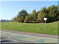
Please do not park on the grass, Pontprennau, Cardiff
A sign at the edge of open space on the north side of Heol Pontprennau states
PLEASE DO NOT PARK ON THE GRASS. CAR PARKING IS AVAILABLE AT THE COMMUNITY CENTRE.
The community centre's car park is little more than 100 metres to the east.
Image: © Jaggery
Taken: 11 Oct 2010
0.17 miles
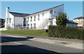
9
Pontprennau Community Church Centre
Find out more about this community centre at http://pontprennaucommunitychurch.blogspot.co.uk/
Image: © Alan Hughes
Taken: 17 Jan 2018
0.18 miles
10
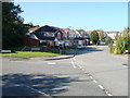
Clonakilty Way, Pontprennau, Cardiff
Heol Pontprennau, from behind the camera, takes a sharp left turn here. Ahead are houses on Clonakilty Way, built in the late 1990s.
Image: © Jaggery
Taken: 11 Oct 2010
0.18 miles