IMAGES TAKEN NEAR TO
Pentwyn Drive, CARDIFF, CF23 7SD
Introduction
This page details the photographs taken nearby to Pentwyn Drive, CF23 7SD by members of the Geograph project.
The Geograph project started in 2005 with the aim of publishing, organising and preserving representative images for every square kilometre of Great Britain, Ireland and the Isle of Man.

There are currently over 7.5m images from over14,400 individuals and you can help contribute to the project by visiting https://www.geograph.org.uk
Image Map
Images are licensed for reuse under creativecommons.org/licenses/by-sa/2.0
Notes
- Clicking on the map will re-center to the selected point.
- The higher the marker number, the further away the image location is from the centre of the postcode.
Image Listing (3 Images Found)
Images are licensed for reuse under creativecommons.org/licenses/by-sa/2.0
Image
Details
Distance
1
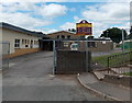
Entrance to St David's Church in Wales Primary School and Ecumenical Church, Cardiff
The school is on the north side of Bryn Celyn Road, Pentwyn, in the NE suburbs of Cardiff.
St David's Ecumenical Church which meets here is part of the Church in Wales Rectorial Benefice of Cyncoed, and a member of Cardiff East Ecumenical Partnership.
Image: © Jaggery
Taken: 10 Aug 2013
0.22 miles
2
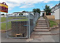
Steps to a path alongside a Pentwyn primary school, Cardiff
The path heads NNE away from Bryn Celyn Road along the perimeter fence of St David's Church in Wales Primary School. http://www.geograph.org.uk/photo/3595772
Image: © Jaggery
Taken: 10 Aug 2013
0.22 miles
3
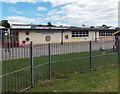
SW corner of a primary school in Pentwyn, Cardiff
St David's Church in Wales Primary School and Ecumenical Church viewed
from Bryn Celyn Road in the NE suburbs of Cardiff.
Image: © Jaggery
Taken: 10 Aug 2013
0.22 miles