IMAGES TAKEN NEAR TO
Brynteg Close, CARDIFF, CF23 6AS
Introduction
This page details the photographs taken nearby to Brynteg Close, CF23 6AS by members of the Geograph project.
The Geograph project started in 2005 with the aim of publishing, organising and preserving representative images for every square kilometre of Great Britain, Ireland and the Isle of Man.

There are currently over 7.5m images from over14,400 individuals and you can help contribute to the project by visiting https://www.geograph.org.uk
Image Map
Images are licensed for reuse under creativecommons.org/licenses/by-sa/2.0
Notes
- Clicking on the map will re-center to the selected point.
- The higher the marker number, the further away the image location is from the centre of the postcode.
Image Listing (18 Images Found)
Images are licensed for reuse under creativecommons.org/licenses/by-sa/2.0
Image
Details
Distance
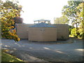
1
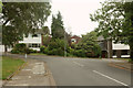
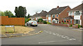
Hunters Ridge meets Cefn Coed Avenue, Cardiff
A T-junction at the other end of the road shown in Image
Image: © Derek Harper
Taken: 16 Jun 2018
0.06 miles
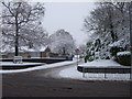
2
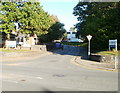
Entrance to UWIC Cyncoed campus, Cardiff
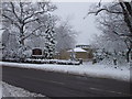
Viewed across Cyncoed Road. The entrance road leads into the University of Wales Institute, Cyncoed Campus. http://www.geograph.org.uk/photo/1661698 to a snowy view of the entrance road.
Image: © Jaggery
Taken: 11 Oct 2010
0.08 miles
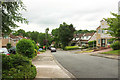
3
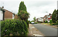
Cefn Coed Avenue, Cardiff
Taken further south than Image], as the residential road breasts a hilltop.
Image: © Derek Harper
Taken: 16 Jun 2018
0.11 miles
5
Hunters Ridge, Cardiff
Torrens Drive is the main road here.
Image: © Derek Harper
Taken: 16 Jun 2018
0.14 miles
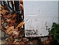
6
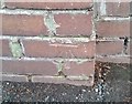
Ordnance Survey Cut Mark
This OS cut mark can be found on the gatepost of No140 Cyncoed Road. It marks a point 58.836m above mean sea level.
Image: © Adrian Dust
Taken: 19 Nov 2017
0.14 miles
8
Cefn Coed Avenue, Cardiff
The road is a cul-de-sac, though there's no problem for pedestrians, which is what I am. Just up ahead is a right turn into Oakdene Close, also a cul-de-sac.
Image: © Derek Harper
Taken: 16 Jun 2018
0.15 miles
9
Ordnance Survey Cut Mark
This OS cut mark can be found on the gatepost of No93 Cyncoed Road. It marks a point 61.472m above mean sea level.
Image: © Adrian Dust
Taken: 19 Nov 2017
0.16 miles
10
St Paul's RC church, Cyncoed
Roman Catholic church set back about 30 metres from the west side of Cyncoed Road, nearly opposite the turning for Woodland Crescent.
Image: © Jaggery
Taken: 11 Oct 2010
0.19 miles