IMAGES TAKEN NEAR TO
Windermere Avenue, CARDIFF, CF23 5PS
Introduction
This page details the photographs taken nearby to Windermere Avenue, CF23 5PS by members of the Geograph project.
The Geograph project started in 2005 with the aim of publishing, organising and preserving representative images for every square kilometre of Great Britain, Ireland and the Isle of Man.

There are currently over 7.5m images from over14,400 individuals and you can help contribute to the project by visiting https://www.geograph.org.uk
Image Map
Images are licensed for reuse under creativecommons.org/licenses/by-sa/2.0
Notes
- Clicking on the map will re-center to the selected point.
- The higher the marker number, the further away the image location is from the centre of the postcode.
Image Listing (107 Images Found)
Images are licensed for reuse under creativecommons.org/licenses/by-sa/2.0
Image
Details
Distance
1

Allotments entrance, Highfield Road, Cardiff
Locked entrance gates to Cardiff Council's Highfields Allotments, which occupy a site on the north side of Highfield Road.
Image: © Jaggery
Taken: 23 Aug 2010
0.03 miles
2

Windermere Avenue, Cardiff
Houses near the northern end of Windermere Avenue, viewed across Highfield Road.
Image: © Jaggery
Taken: 23 Aug 2010
0.03 miles
3
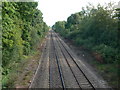
Looking south along the Cardiff to Rhymney railway line
From the Highfield Road bridge.
Image: © Eirian Evans
Taken: 17 Jul 2010
0.04 miles
4
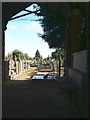
A glimpse into the Jewish Cemetery
The first formal Jewish institution to be established in Cardiff was a Jewish cemetery at Highfield in 1841.
Image: © Eirian Evans
Taken: 17 Jul 2010
0.05 miles
5
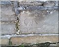
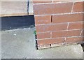
Ordnance Survey Cut Mark
This OS cut mark can be found on the wall of the Cemetery, Highfield Road. It marks a point 35,659m above mean sea level.
Image: © Adrian Dust
Taken: 19 Nov 2017
0.05 miles
6
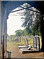
Jewish Cemetery, Cardiff
A glimpse through the doorway of Cardiff’s Jewish Cemetery.
Image: © Alan Hughes
Taken: 9 Sep 2022
0.05 miles
7

Geese, Roath Park Lake, Cardiff
Viewed from near the corner of Highfield Road and Lake Road West. The houses on the far side of the lake are on Lake Road East.
Image: © Jaggery
Taken: 23 Aug 2010
0.06 miles
8

Cardiff : Lake Road West houses
The houses are immediately north of the junction with Highfield Road.
Image: © Jaggery
Taken: 23 Aug 2010
0.06 miles
9
Ordnance Survey Cut Mark
This OS cut mark can be found on No137 Lake Road West. It marks a point 24.378m above mean sea level.
Image: © Adrian Dust
Taken: 19 Nov 2017
0.06 miles
10
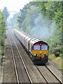
Freight train near Heath Junction
DB class 66 No. 66039 powers upgrade towards Heath Junction with a Hope-to-Cwmbargoed empty coal train working.
Image: © Gareth James
Taken: 13 Aug 2018
0.06 miles