1
Albion House, Oxford Street, Nantgarw
Modern office block alongside the A4054. An estate agents' board shows that one of the office suites was available to let at the early January 2012 date of this view.
Image: © Jaggery
Taken: 6 Jan 2012
0.01 miles
2
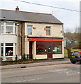
Chan's Chinese Kitchen, Nantgarw
Chinese takeaway at 1 Oxford Street.
Image: © Jaggery
Taken: 6 Jan 2012
0.02 miles
3
Sculpture beside a roundabout
The sculpture is based on the coal mining heritage.
Image: © DS Pugh
Taken: 24 Jun 2024
0.06 miles
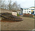
4
Former colliery winding wheel at the southern entrance to Parc Nantgarw
The winding wheel is a reminder that Parc Nantgarw, now a business, retail and leisure area,
occupies the site of the former Nantgarw Colliery.
Image: © Jaggery
Taken: 6 Jan 2012
0.06 miles
5
Roundabout on Caerphilly Road
The junction of Oxford Street, Cardiff Road and Caerphilly Road.
Image: © DS Pugh
Taken: 24 Jun 2024
0.06 miles
6
Cycle route, Nantgarw
Sturdy metal posts prevent anything wider than a 2-wheel vehicle using the cycle route, which was formerly a railway. Viewed from the edge of the A4054.
Image: © Jaggery
Taken: 6 Jan 2012
0.06 miles
7
Nantgarw Colliery & Coking Plant, Treforest Industrial Estate, 1973
Photographer: Ben Brooksbank http://www.geograph.org.uk/profile/44502
Taken by the side of the A468 (the route to Caerphilly lying behind the camera), looking towards its roundabout with what was then the A470 from Cardiff to Merthyr Tydfil. The sign indicates that one should double back (first left) for Taff's Well and Cardiff. The old A470 is now designated the A4054. The curve and downgrade are still essentially the same, but the roundabout now has an extra industrial estate turnoff on the right. This area had a complex rail network, with lines running down both sides of Taff Vale, and with another line running right through the middle of the industrial estate. By the time this photo was taken, that 'central' line had been reduced to a short spur running from the South to the colliery. The embankment of that line is visible in this photo, to the left of the roundabout, with the River Taff beyond. The colliery and coking plant closed in 1986, and the entire plant and embankment have since been flattened.The old house on the right was originally part of the historic Nantgarw Chinaworks, and is now its museum. The remains of the Glamorganshire Canal are also to be found in the vicinity of the chinaworks. The A470 Expressway now thunders over a roundabout intersection both behind and just to the East of the photographer's position - making the pictured foreground road a sliproad for the industrial estate.
Wikipedia entries for Nantgarw & Treforest: http://en.wikipedia.org/wiki/Nantgarw
http://en.wikipedia.org/wiki/Treforest
Nantgarw Colliery: http://www.welshcoalmines.co.uk/GlamEast/Nantgarw.htm
Image: © Ben Brooksbank: http://www.geograph.org.uk/profile/44502
Taken: 29 Sep 1973
0.07 miles
8
Southern entrance to Parc Nantgarw, Nantgarw
Viewed from the A4054. Parc Nantgarw, a business, retail and leisure area, occupies the site of the former Nantgarw Colliery. There is a pit winding wheel http://www.geograph.org.uk/photo/3191055 at the entrance, on the left.
ESIS Conference Centre http://www.geograph.org.uk/photo/3191067 is in the background.
Image: © Jaggery
Taken: 6 Jan 2012
0.08 miles
9
Nantgarw Colliery from A470 Taff Vale road, 1962
View NW, towards Pontypridd. The Colliery was closed in 1986 and this is now the industrial Parc Nantgarw. Everything is totally different 50 years later.
Image: © Ben Brooksbank
Taken: 31 May 1962
0.09 miles
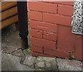
10
Ordnance Survey Cut Mark
This OS cut mark can be found on No51 Oxford Street. It marks a point 36.692m above mean sea level.
Image: © Adrian Dust
Taken: 17 Aug 2019
0.12 miles


