IMAGES TAKEN NEAR TO
Duffryn Ffrwd, CARDIFF, CF15 7TP
Introduction
This page details the photographs taken nearby to Duffryn Ffrwd, CF15 7TP by members of the Geograph project.
The Geograph project started in 2005 with the aim of publishing, organising and preserving representative images for every square kilometre of Great Britain, Ireland and the Isle of Man.

There are currently over 7.5m images from over14,400 individuals and you can help contribute to the project by visiting https://www.geograph.org.uk
Image Map
Images are licensed for reuse under creativecommons.org/licenses/by-sa/2.0
Notes
- Clicking on the map will re-center to the selected point.
- The higher the marker number, the further away the image location is from the centre of the postcode.
Image Listing (14 Images Found)
Images are licensed for reuse under creativecommons.org/licenses/by-sa/2.0
Image
Details
Distance
3
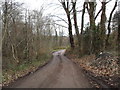
Nantgarw
A track off the A469 to Bwlch-y-Maen.
Image: © Burgess Von Thunen
Taken: 25 Jan 2012
0.14 miles
4
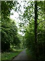
Bridge near Caerphilly Road
The path is a link onto the cycle path between Nantgarw and Caerphilly along the former Penrhos Branch railway and is part of National Cycle Network route 4.
Image: © DS Pugh
Taken: 24 Jun 2024
0.18 miles
5
Taff Trail/Celtic Trail junction
The left hand fork ahead leads north along the Taff Trail/Celtic Trail towards Pontypridd. The right hand fork heads east along the Celtic Trail towards Caerphilly. The route behind me is the Taff Trail heading towards Cardiff. The sign in the background is the subject of Image
Image: © John Light
Taken: 1 Dec 2012
0.18 miles
6
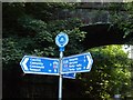
The Taff Trail Junction of National Cycleway Routes 4 and 8.
The route of the Taff Trail from Taffs Well follows the former Rhymney Railway. At this point Cycleway Route 4 (east) continues in the deep Penrhos Cutting towards Caerphilly. Routes 4(west) and 8(North) continue over the same course towards Pontypridd.
Image: © Robin Williams
Taken: 22 Aug 2005
0.18 miles
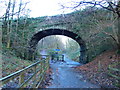
7
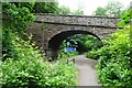
Old railway bridge, near Taff's Well
The former Rhymney Railway between Taff's Well and Aber (near Caerphilly) passed over this bridge; the route is now part of the Taff Trail.
Image: © Gareth James
Taken: 21 Feb 2009
0.18 miles
8
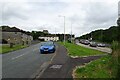
Path to Caerphilly Road
Caerphilly Road is on the right and is numbered as the A468.
Image: © DS Pugh
Taken: 24 Jun 2024
0.21 miles
9

Path descending from Caerphilly Road
The path is a link onto the cycle path between Nantgarw and Caerphilly along the former Penrhos Branch railway and is part of National Cycle Network route 4.
Image: © DS Pugh
Taken: 24 Jun 2024
0.22 miles
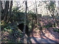
10
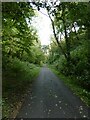
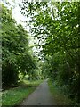
Sustrans NCN 4 passing Nantgarw
The cycle route follows an old railway line through woodland
Image: © David Smith
Taken: 22 Sep 2022
0.23 miles