IMAGES TAKEN NEAR TO
Heol Y Pwll, Parc Nantgarw, CARDIFF, CF15 7QW
Introduction
This page details the photographs taken nearby to Heol Y Pwll, Parc Nantgarw, CF15 7QW by members of the Geograph project.
The Geograph project started in 2005 with the aim of publishing, organising and preserving representative images for every square kilometre of Great Britain, Ireland and the Isle of Man.

There are currently over 7.5m images from over14,400 individuals and you can help contribute to the project by visiting https://www.geograph.org.uk
Image Map
Images are licensed for reuse under creativecommons.org/licenses/by-sa/2.0
Notes
- Clicking on the map will re-center to the selected point.
- The higher the marker number, the further away the image location is from the centre of the postcode.
Image Listing (35 Images Found)
Images are licensed for reuse under creativecommons.org/licenses/by-sa/2.0
Image
Details
Distance
1
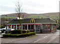
McDonald's, Parc Nantgarw
Parc Nantgarw occupies the site of the former Nantgarw Colliery.
Image: © Jaggery
Taken: 6 Jan 2012
0.03 miles
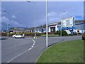
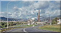
2
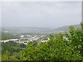
Treforest Industrial Estate and the Taff Valley
Image: © Colin Bell
Taken: 8 May 2007
0.05 miles
3
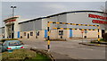
Showcase Cinemas, Parc Nantgarw
The 12-screen cinema has free parking, including spaces for Blue Badge holders.
Image: © Jaggery
Taken: 6 Jan 2012
0.07 miles
4
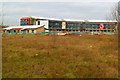
Taf Ely Learning Campus, Parc Nantgarw
This early January 2012 view from Heol Crochendy shows that construction work
on the new Coleg Morgannwg campus in Nantgarw is nearing completion.
Image: © Jaggery
Taken: 6 Jan 2012
0.08 miles
5

Showcase Cinema
Showcase Cinema, Nantgarw, near Cardiff.
Image: © Peter Wasp
Taken: 14 Mar 2007
0.08 miles
6
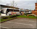
Ferris coaches in Parc Nantgarw
The coaches are parked on the side of Heol Crochendy, the main road through Parc Nantgarw.
Based nearby in The Coach House, Cardiff Road, Nantgarw,http://www.geograph.org.uk/photo/2730797 Ferris Holidays Ltd,
established in 1981, provides coach holidays and coach hire.
Image: © Jaggery
Taken: 6 Jan 2012
0.09 miles
8
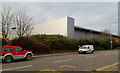
Makro, Parc Nantgarw
Makro occupies large premises in Heol y Pwll, Parc Nantgarw.
Makro stocks and delivers a wide range of wholesale items for caterers.
Image: © Jaggery
Taken: 6 Jan 2012
0.10 miles
9
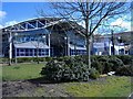
Coleg Morgannwg
The Nantgarw campus.
Image: © Roger Cornfoot
Taken: 19 Mar 2007
0.11 miles
10
Nantgarw Colliery & Coking Plant, Treforest Industrial Estate, 1973
Photographer: Ben Brooksbank http://www.geograph.org.uk/profile/44502
Taken by the side of the A468 (the route to Caerphilly lying behind the camera), looking towards its roundabout with what was then the A470 from Cardiff to Merthyr Tydfil. The sign indicates that one should double back (first left) for Taff's Well and Cardiff. The old A470 is now designated the A4054. The curve and downgrade are still essentially the same, but the roundabout now has an extra industrial estate turnoff on the right. This area had a complex rail network, with lines running down both sides of Taff Vale, and with another line running right through the middle of the industrial estate. By the time this photo was taken, that 'central' line had been reduced to a short spur running from the South to the colliery. The embankment of that line is visible in this photo, to the left of the roundabout, with the River Taff beyond. The colliery and coking plant closed in 1986, and the entire plant and embankment have since been flattened.The old house on the right was originally part of the historic Nantgarw Chinaworks, and is now its museum. The remains of the Glamorganshire Canal are also to be found in the vicinity of the chinaworks. The A470 Expressway now thunders over a roundabout intersection both behind and just to the East of the photographer's position - making the pictured foreground road a sliproad for the industrial estate.
Wikipedia entries for Nantgarw & Treforest: http://en.wikipedia.org/wiki/Nantgarw
http://en.wikipedia.org/wiki/Treforest
Nantgarw Colliery: http://www.welshcoalmines.co.uk/GlamEast/Nantgarw.htm
Image: © Ben Brooksbank: http://www.geograph.org.uk/profile/44502
Taken: 29 Sep 1973
0.14 miles