IMAGES TAKEN NEAR TO
Moy Road, CARDIFF, CF15 7PW
Introduction
This page details the photographs taken nearby to Moy Road, CF15 7PW by members of the Geograph project.
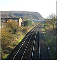
The Geograph project started in 2005 with the aim of publishing, organising and preserving representative images for every square kilometre of Great Britain, Ireland and the Isle of Man.

There are currently over 7.5m images from over14,400 individuals and you can help contribute to the project by visiting https://www.geograph.org.uk
Image Map
Images are licensed for reuse under creativecommons.org/licenses/by-sa/2.0
Notes
- Clicking on the map will re-center to the selected point.
- The higher the marker number, the further away the image location is from the centre of the postcode.
Image Listing (50 Images Found)
Images are licensed for reuse under creativecommons.org/licenses/by-sa/2.0
Image
Details
Distance
1
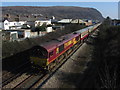
Railtour at Taffs Well
UK Railtours' The Tower Gateway railtour visited the freight-only branches to Cwmbargoed and Tower Colliery. Here the tours heads north from Taffs Well station on its trip out to the latter, with locomotive No. 66250 in charge.
Image: © Gareth James
Taken: 9 Mar 2014
0.03 miles
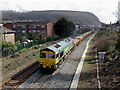
2
Coal train near Taff's Well
An Aberthaw power station to Tower colliery train of empty coal hoppers heads north through Taff's Well headed by Freightliner's class 66 locomotive No. 66564.
Image: © Gareth James
Taken: 26 Nov 2016
0.04 miles
3
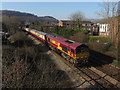
Railtour at Taffs Well
UK Railtours' The Tower Gateway railtour visited the freight-only branches to Cwmbargoed and Tower Colliery. Here the tours heads north from Taffs Well station on its trip out to the latter, with locomotive No. 66021 bringing up the rear.
Image: © Gareth James
Taken: 9 Mar 2014
0.06 miles
4
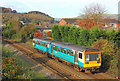
Taffs Well
Valley Lines train near Taffs Well.
Image: © Wayland Smith
Taken: 5 Nov 2011
0.07 miles
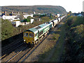
5
Coal train near Taff's Well
An unidentified Freightliner class 66 locomotive runs through Taff's Well with the 10:54 loaded working from Tower Colliery to Aberthaw Power Station.
Image: © Gareth James
Taken: 21 Jan 2017
0.07 miles
6
Sycamore Street, Taffs Well
Viewed from Cardiff Road. Sycamore Street is a cul-de-sac ending at a footbridge http://www.geograph.org.uk/photo/2730537 across railway lines.
Image: © Jaggery
Taken: 9 Dec 2011
0.08 miles
7
Sycamore Street footbridge viewed from Cardiff Road, Glan-y-llyn
The footbridge connects Sycamore Street http://www.geograph.org.uk/photo/2730521 Taffs Well on the right side with Moy Road on the left. The railway lines are between Taffs Well and Treforest stations.
Image: © Jaggery
Taken: 9 Dec 2011
0.08 miles
8
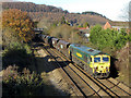
Coal train near Taff's Well
A Tower colliery to Aberthaw power station train of loaded coal hoppers heads south through Taff's Well headed by Freightliner's class 66 locomotive No. 66516.
Image: © Gareth James
Taken: 26 Nov 2016
0.09 miles
9
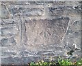
Ordnance Survey Cut Mark
This OS cut mark can be found on the wall of No109 Cardiff Road. It marks a point 36.207m above mean sea level.
Image: © Adrian Dust
Taken: 20 Jul 2020
0.09 miles
10
Ballast train in Taffs Well
Freightliner class 66 No. 66547 heads a Westbury to Abercynon working of fresh ballast through Taffs Well; classmate No. 66532 is on the rear.
Image: © Gareth James
Taken: 24 Mar 2023
0.10 miles