IMAGES TAKEN NEAR TO
Cardiff Road, CARDIFF, CF15 7PQ
Introduction
This page details the photographs taken nearby to Cardiff Road, CF15 7PQ by members of the Geograph project.
The Geograph project started in 2005 with the aim of publishing, organising and preserving representative images for every square kilometre of Great Britain, Ireland and the Isle of Man.

There are currently over 7.5m images from over14,400 individuals and you can help contribute to the project by visiting https://www.geograph.org.uk
Image Map
Images are licensed for reuse under creativecommons.org/licenses/by-sa/2.0
Notes
- Clicking on the map will re-center to the selected point.
- The higher the marker number, the further away the image location is from the centre of the postcode.
Image Listing (45 Images Found)
Images are licensed for reuse under creativecommons.org/licenses/by-sa/2.0
Image
Details
Distance
1
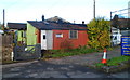
Small corrugated metal building, Taffs Well
Located opposite the local library, http://www.geograph.org.uk/photo/2729385 set back about 40 metres from the east side of Cardiff Road.
Image: © Jaggery
Taken: 9 Dec 2011
0.01 miles
2
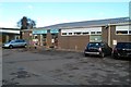
Medical facilities, Taffs Well
Set back 80 metres from Cardiff Road are The Medical Centre and a Lloyds Pharmacy.
Taffs Well Library is nearby. http://www.geograph.org.uk/photo/2729385
Image: © Jaggery
Taken: 9 Dec 2011
0.01 miles
3
Taffs Well Library
Set back 50 metres from the east side of Cardiff Road, Taffs Well Library is part of the Rhondda Cynon Taf library service. The library has been in this building since August 1976.
Image: © Jaggery
Taken: 9 Dec 2011
0.01 miles
4
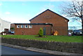
Taffs Well Village Hall
Located on Cardiff Road, Taffs Well. The hall is used for recreational and educational activities and is available for hire.
Image: © Jaggery
Taken: 9 Dec 2011
0.07 miles
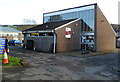
5
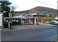
Derelict former Repsol garage, Taffs Well
The Cardiff Road premises appear to have been disused for several years.
Image: © Jaggery
Taken: 9 Dec 2011
0.07 miles
6
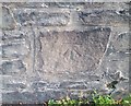
Ordnance Survey Cut Mark
This OS cut mark can be found on the wall of No109 Cardiff Road. It marks a point 36.207m above mean sea level.
Image: © Adrian Dust
Taken: 20 Jul 2020
0.07 miles
7
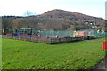
Children's play area,Taffs Well Park
Beyond the play area are tennis courts. The park is located on the east bank of the River Taff.
Garth Hill Image is in the distance.
Image: © Jaggery
Taken: 9 Dec 2011
0.08 miles
8
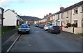
King Street, Taffs Well
Looking along King Street towards Garth Street. Church Street is behind the camera.
Image: © Jaggery
Taken: 9 Dec 2011
0.09 miles
9
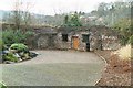
The well in Taffs Well
The old well (ffynnon) on the banks of the river Taff
Image: © Eryl Samuel
Taken: 6 Dec 2002
0.11 miles
10
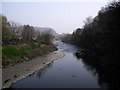
View downstream from the footbridge at Gwaelod-y-garth
Image: © John Lord
Taken: 27 Mar 2011
0.12 miles