IMAGES TAKEN NEAR TO
Rhiw'r Ddar, CARDIFF, CF15 7PD
Introduction
This page details the photographs taken nearby to Rhiw'r Ddar, CF15 7PD by members of the Geograph project.
The Geograph project started in 2005 with the aim of publishing, organising and preserving representative images for every square kilometre of Great Britain, Ireland and the Isle of Man.

There are currently over 7.5m images from over14,400 individuals and you can help contribute to the project by visiting https://www.geograph.org.uk
Image Map (Loading...)


Getting Data...Please wait
Leaflet Map data © OpenStreetMap
Images are licensed for reuse under creativecommons.org/licenses/by-sa/2.0
Notes
- Clicking on the map will re-center to the selected point.
- The higher the marker number, the further away the image location is from the centre of the postcode.
Image Listing (9 Images Found)
Images are licensed for reuse under creativecommons.org/licenses/by-sa/2.0
Image
Details
Distance
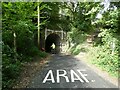
1
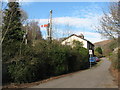
Taff Trail, heading north from Taff's Well
The cycle trail on the route of the former railway from Taff's Well to Aber (note the semaphore signal still standing).
Image: © Gareth James
Taken: 21 Feb 2009
0.10 miles
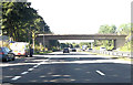
4
Road bridge connecting parts of Glan-y-llyn
The bridge over the A470 connects the industrial estates on the left with the housing estates on the right. Both areas are screened from some traffic noise by trees.
Image: © David Smith
Taken: 7 Jul 2011
0.12 miles
5
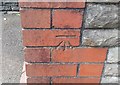
Ordnance Survey Cut Mark
This OS cut mark can be found on the NE face of the Cemetery Chapel. It marks a point 59.529m above mean sea level.
Image: © Adrian Dust
Taken: 17 Aug 2019
0.15 miles
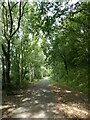
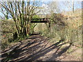
6
Bridge over temporary section of Taff Trail
At the time of the picture, the Taff Trail had been diverted for construction of a light railway, so the real trail is on the bridge above
Image: © David Smith
Taken: 22 Sep 2022
0.20 miles
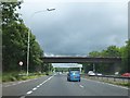
7
Pont Glan y Llyn Bridge
Pont yn croesi hen rheilffordd sy bellach yn Llwybr Taf yng Nglan y Llyn.
A bridge near Glan y Llyn (trans. lake side) spanning the former railway which is nowadays the Taff Trail
Image: © Alan Richards
Taken: 23 Mar 2014
0.20 miles
8
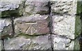
Ordnance Survey Cut Mark
This OS cut mark can be found on the abutment of the Railway Bridge. It marks a point 38.949m above mean sea level.
Image: © Adrian Dust
Taken: 17 Aug 2019
0.21 miles
9

Industrial estate
Factory unit on Glan y Llyn Square industrial estate.
Image: © Alan Hughes
Taken: 5 Jun 2019
0.24 miles