1
Capel Glandwr Taf, Taffs Well
Welsh non-conformist chapel built in 1859 and converted for residential use in 1997.
Image: © Alan Hughes
Taken: 5 Jun 2019
0.01 miles
2
Ordnance Survey Rivet
This OS rivet can be found on the east parapet of the bridge. It marks a point 42.679m above mean sea level.
Image: © Adrian Dust
Taken: 20 Jul 2020
0.04 miles
3
Glan-y-Llyn village entrance, Cardiff Road
Image: © Colin Pyle
Taken: 4 Jan 2011
0.04 miles
4
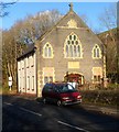
Former Glandwr Taf Welsh Independent chapel near Glan-y-llyn
Converted into a dwelling in 1997, with the front of the former chapel preserved.
A faded stone inscription in Welsh shows that the chapel opened in 1859.
Located on the east side of Cardiff Road between Glan-y-llyn and Nantgarw.
Image: © Jaggery
Taken: 9 Dec 2011
0.06 miles
5
Swan Inn, Glan-y-llyn
Located at 68 Cardiff Road, on the east bank of the River Taff.
Image: © Jaggery
Taken: 9 Dec 2011
0.09 miles
6
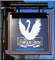
The Swan Inn name sign, Glan-y-llyn
The inn http://www.geograph.org.uk/photo/2730595 is at 68 Cardiff Road.
Image: © Jaggery
Taken: 9 Dec 2011
0.09 miles
7
The Spice Connoisseur, Glan-y-llyn
Indian restaurant and takeaway located in Garth View House, Cardiff Road.
Image: © Jaggery
Taken: 9 Dec 2011
0.09 miles
8
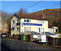
Northern boundary of Glan-y-llyn
The A4054 (Cardiff Road) reaches the north edge of Glan-y-llyn, a small village in Rhondda Cynon Taf County Borough. The village's southern boundary is with Taffs Well. The row of bungalows http://www.geograph.org.uk/photo/2730576 is Stradmore Close.
Image: © Jaggery
Taken: 9 Dec 2011
0.09 miles
9
Ordnance Survey Cut Mark
This OS cut mark can be found on the east buttress of the railway bridge. It marks a point 37.328m above mean sea level.
Image: © Adrian Dust
Taken: 20 Jul 2020
0.11 miles
10
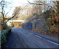
Remnants of the Cardiff Railway near Nantgarw
This view north along the A4054 towards a footbridge shows stonework on the right, remnants of an embankment on the Cardiff Railway, which was absorbed by the Great Western Railway on January 1 1922 under the terms of the Railways Act 1921. The letters CR (Cardiff Railway) are visible near the top of the column in the middle of the stonework.
The original railway bridge is long gone. The modern footbridge carries a footpath and cycle way which use the trackbed of the dismantled railway.
Image: © Jaggery
Taken: 9 Dec 2011
0.12 miles


