IMAGES TAKEN NEAR TO
Pwllhelyg, CARDIFF, CF15 7HX
Introduction
This page details the photographs taken nearby to Pwllhelyg, CF15 7HX by members of the Geograph project.
The Geograph project started in 2005 with the aim of publishing, organising and preserving representative images for every square kilometre of Great Britain, Ireland and the Isle of Man.

There are currently over 7.5m images from over14,400 individuals and you can help contribute to the project by visiting https://www.geograph.org.uk
Image Map
Images are licensed for reuse under creativecommons.org/licenses/by-sa/2.0
Notes
- Clicking on the map will re-center to the selected point.
- The higher the marker number, the further away the image location is from the centre of the postcode.
Image Listing (49 Images Found)
Images are licensed for reuse under creativecommons.org/licenses/by-sa/2.0
Image
Details
Distance
1
Bus stops, eastern edge of Tongwynlais
The bus stops are on Merthyr Road (A4054). Although Tongwynlais has been absorbed into the City of Cardiff, Cardiff Bus does not have a service to the village. Most buses through Tongwynlais are provided by Stagecoach.
Image: © Jaggery
Taken: 29 Nov 2010
0.02 miles
2

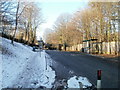
Start of cycle route, Merthyr Road, Tongwynlais
At the eastern edge of Tongwynlais, a footpath and cycle route heads away SSE from Merthyr Road.
The sign on the right has an arrow pointing along the route and shows Pantmawr and Whitchurch.
Image: © Jaggery
Taken: 29 Nov 2010
0.02 miles
3
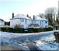
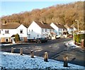
Castle View, Tongwynlais
Houses at the western end of Castle View, on the corner of Pantgwynlais (a residential road).
Image: © Jaggery
Taken: 29 Nov 2010
0.05 miles
4
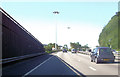
M4 J32 interchange
Looking towards the A470 southbound off slip.
Image: © Gareth James
Taken: 5 Dec 2015
0.06 miles
5
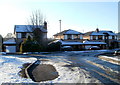
Cwm Gwynlais, Tongwynlais
Houses near the eastern edge of Tongwynlais, on a street named Cwm Gwynlais, at the corner of Pwllhelyg (on the left). Cwm Gwynlais connects with Merthyr Road, a few metres behind the camera.
Image: © Jaggery
Taken: 29 Nov 2010
0.07 miles
6

Cycle route footbridge near Tongwynlais
A footbridge carries a combined footpath and cycle route across the road connecting the A470 and A4054.
Image: © Jaggery
Taken: 29 Nov 2010
0.08 miles
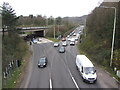
7

NW edge of the Coryton Interchange, Cardiff
The Coryton Interchange is a major group of junctions near the northern edge of Cardiff. It includes junction 32 of the M4, the A4054 and the A470. This view, from a footbridge, http://www.geograph.org.uk/photo/2181859 shows a junction of A4054 and A470 slip roads. The bridge carries the A470, here named Northern Avenue.
Image: © Jaggery
Taken: 29 Nov 2010
0.08 miles
8
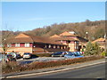
Cardiff International Hotel
Formerly known as the Quality Hotel. Located on the northern edge of Coryton Interchange (this includes M4 motorway junction 32) near the eastern edge of Tongwynlais. The hotel has 95 guest rooms.
Image: © Jaggery
Taken: 29 Nov 2010
0.11 miles
9
West side of Greenmeadow Drive, Tongwynlais
Viewed from the corner of Pantgwynlais (a residential road). In the background is Greenmeadow Wood.
Image: © Jaggery
Taken: 29 Nov 2010
0.13 miles