IMAGES TAKEN NEAR TO
Clos Y Ceinach, CARDIFF, CF14 9EX
Introduction
This page details the photographs taken nearby to Clos Y Ceinach, CF14 9EX by members of the Geograph project.
The Geograph project started in 2005 with the aim of publishing, organising and preserving representative images for every square kilometre of Great Britain, Ireland and the Isle of Man.

There are currently over 7.5m images from over14,400 individuals and you can help contribute to the project by visiting https://www.geograph.org.uk
Image Map
Images are licensed for reuse under creativecommons.org/licenses/by-sa/2.0
Notes
- Clicking on the map will re-center to the selected point.
- The higher the marker number, the further away the image location is from the centre of the postcode.
Image Listing (8 Images Found)
Images are licensed for reuse under creativecommons.org/licenses/by-sa/2.0
Image
Details
Distance
1
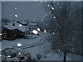
Snow in Brookvale Drive,Cardiff.
Taken when Cardiff came to a standstill in February, taken from garage roof.
Image: © Gerard Greene
Taken: 8 Feb 2007
0.16 miles
2
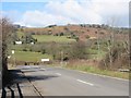
Heol Hir and Capel Gwilym Road 'T' Junction
The photograph was taken from a motorway bridge on the M4. The hill in the distance is Graig Llanishen.
Image: © Roy Douglas
Taken: Unknown
0.20 miles
3
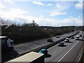
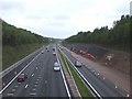
M4 skirting North Cardiff
Photograph taken from a motoraway bridge. To the south the extremity of the Thornhill housing development can be seen.
Image: © Roy Douglas
Taken: Unknown
0.20 miles
5
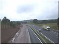
M4, looking west
Photograph taken from Heol Hir,during widening work
Image: © John Lord
Taken: 26 Aug 2008
0.21 miles
6
M4, looking east
Photograph taken from Heol Hir, during the widening work
Image: © John Lord
Taken: 26 Aug 2008
0.21 miles
7
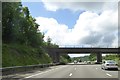
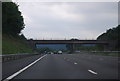
Heol Hir road bridge over M4 on the edge of Cardiff
Image: © David Smith
Taken: 1 Jun 2018
0.22 miles
8
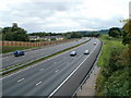
Westbound M4 viewed from Heol Hir, Cardiff
Heol Hir is at the northern edge of Thornhill, Cardiff
Image: © Jaggery
Taken: 12 Aug 2010
0.24 miles