IMAGES TAKEN NEAR TO
Wavell Close, CARDIFF, CF14 5LQ
Introduction
This page details the photographs taken nearby to Wavell Close, CF14 5LQ by members of the Geograph project.
The Geograph project started in 2005 with the aim of publishing, organising and preserving representative images for every square kilometre of Great Britain, Ireland and the Isle of Man.

There are currently over 7.5m images from over14,400 individuals and you can help contribute to the project by visiting https://www.geograph.org.uk
Image Map
Images are licensed for reuse under creativecommons.org/licenses/by-sa/2.0
Notes
- Clicking on the map will re-center to the selected point.
- The higher the marker number, the further away the image location is from the centre of the postcode.
Image Listing (43 Images Found)
Images are licensed for reuse under creativecommons.org/licenses/by-sa/2.0
Image
Details
Distance
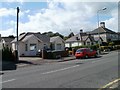
1
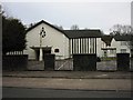
St Brigid's RC Church
Situated at the junction of Crystal Glen and Fishguard Close
Image: © Roy Douglas
Taken: Unknown
0.04 miles
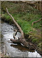
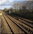
3
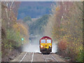
Rail-head treatment train near Heath
A rail-head treatment train is seen in action as it descends between Llanishen and Heath High Level station with class 66 No. 66183 in charge.
Image: © Gareth James
Taken: 3 Dec 2020
0.13 miles
4
Corner of Fidlas Avenue and Fidlas Road, Cardiff
The southern edge of Fidlas Avenue viewed across Fidlas Road. The central part of Fidlas Avenue follows a course parallel with Fidlas Road, which it rejoins about 350 metres north of this point.
Image: © Jaggery
Taken: 23 Aug 2010
0.15 miles
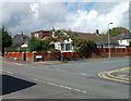
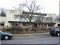
5
Bungalows, Fidlas Road, Cardiff
Located on the west side of Fidlas Road, immediately north of a row of shops. http://www.geograph.org.uk/photo/2030243
Image: © Jaggery
Taken: 23 Aug 2010
0.15 miles
6
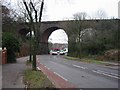
Three Arches Railway Bridge, Heath
A famous local landmark.At the Cyncoed end of Heathwood Road
Image: © Roy Douglas
Taken: Unknown
0.17 miles
7
Three Arches Public House
Beside the Three Arches Railway Bridge
Image: © Roy Douglas
Taken: Unknown
0.17 miles
8
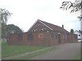
Llanishen Evangelical Church, Cardiff
In 1953 an evangelist Stan Ford held a gospel campaign in a large tent where the church now stands. The tent remained on the site after this, and a Sunday School and other meetings were held in it until it blew down in a gale. In 1954 a metal hut, dismantled from a site in Bedlinog, was erected here and a church was commenced, its opening service being on Sat. 15th May. The present brick-built chapel was opened on 7th March 1959, and an extension added in 1976. The church was originally called Llanishen Gospel Hall, then Emmaus Chapel, before the present name.
Image: © John Lord
Taken: 26 Aug 2008
0.18 miles
9
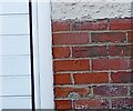
Ordnance Survey Cut Mark
This OS cut mark can be found on No23 Fidlas Road. It marks a point 36.771m above mean sea level.
Image: © Adrian Dust
Taken: 26 Feb 2024
0.18 miles
10
Rhymney Line north towards Llanishen, Cardiff
Viewed from the northern end of Heath High Level station looking along the Rhymney Line.
The next station ahead is Llanishen (Cardiff), about 1.8km (a little over a mile) ahead.
Image: © Jaggery
Taken: 28 Jan 2016
0.18 miles