IMAGES TAKEN NEAR TO
Smith Road, CARDIFF, CF14 5EU
Introduction
This page details the photographs taken nearby to Smith Road, CF14 5EU by members of the Geograph project.
The Geograph project started in 2005 with the aim of publishing, organising and preserving representative images for every square kilometre of Great Britain, Ireland and the Isle of Man.

There are currently over 7.5m images from over14,400 individuals and you can help contribute to the project by visiting https://www.geograph.org.uk
Image Map
Images are licensed for reuse under creativecommons.org/licenses/by-sa/2.0
Notes
- Clicking on the map will re-center to the selected point.
- The higher the marker number, the further away the image location is from the centre of the postcode.
Image Listing (132 Images Found)
Images are licensed for reuse under creativecommons.org/licenses/by-sa/2.0
Image
Details
Distance
1
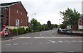
Junction at the western end of Smith Road, Cardiff
Smith Road leads to Pentland Close. Except for buses, Smith Road is not a through route for motor vehicles.
Image: © Jaggery
Taken: 21 Jun 2016
0.02 miles
2
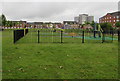
Children's play area north of Smith Road, Cardiff
Opposite Llys Enfys. http://www.geograph.org.uk/photo/5011044
Image: © Jaggery
Taken: 21 Jun 2016
0.02 miles
3
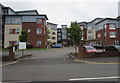
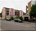
Llys Enfys, Cardiff
Linc Cymru community housing and care scheme for older people which was developed in partnership with Cardiff City Council. Llys Enfys has 102 self-contained apartments.
Image: © Jaggery
Taken: 21 Jun 2016
0.04 miles
4

Ffordd Mograig, Cardiff
Looking south along the road named Ffordd Mograig from the corner of Smith Road.
A nearby street name sign shows that Ffordd Mograig leads to Tasker Square.
Image: © Jaggery
Taken: 21 Jun 2016
0.06 miles
5
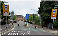
Warning signs - rising bollards, Malvern Drive, Cardiff
On the approach to Smith Road.
Image: © Jaggery
Taken: 21 Jun 2016
0.06 miles
6
Pentland Close electricity substation, Cardiff
The Western Power Distribution electricity substation on the right is near the corner of Malvern Drive.
Image: © Jaggery
Taken: 21 Jun 2016
0.07 miles
7
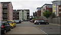
Pentland Close multi-storey blocks of flats, Cardiff
On the south side of Smith Road.
Image: © Jaggery
Taken: 21 Jun 2016
0.08 miles
8
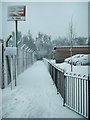
Pedestrian access to Ty Glas railway station
A short path from the end of the Pentland Close leads to Ty Glas railway station.
Image: © Martyn Harries
Taken: 13 Jan 2010
0.09 miles
9
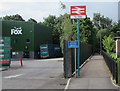
Ty Glas railway station name sign, Cardiff
Facing Pentland Close. The path leads to the single-platform Ty Glas station http://www.geograph.org.uk/photo/5010641 on the Coryton Line.
The entrance to a Fox depot http://www.geograph.org.uk/photo/5010786 is on the left.
Image: © Jaggery
Taken: 21 Jun 2016
0.09 miles
10

Track work underway around Birchgrove station
Track work took place around Birchgrove station on the single-line Coryton branch on Sunday, 2nd February 2020. The work saw the existing track cut into panels and moved aside; the spent ballast removed, a new membrane and fresh ballast laid; the track panels lifted back to re-use the sleepers with the rails then being discarded; new rails installed and clipped; and further ballast laid and the tracked tamped in time for Monday morning's first train.
This is the view east from Caerphilly Road overbridge towards Ty Glas station. Sleepers have been relaid and the new rail is about to be clipped into place.
Image: © Gareth James
Taken: 2 Feb 2020
0.09 miles