IMAGES TAKEN NEAR TO
Heol Hir, CARDIFF, CF14 5AB
Introduction
This page details the photographs taken nearby to Heol Hir, CF14 5AB by members of the Geograph project.
The Geograph project started in 2005 with the aim of publishing, organising and preserving representative images for every square kilometre of Great Britain, Ireland and the Isle of Man.

There are currently over 7.5m images from over14,400 individuals and you can help contribute to the project by visiting https://www.geograph.org.uk
Image Map
Images are licensed for reuse under creativecommons.org/licenses/by-sa/2.0
Notes
- Clicking on the map will re-center to the selected point.
- The higher the marker number, the further away the image location is from the centre of the postcode.
Image Listing (22 Images Found)
Images are licensed for reuse under creativecommons.org/licenses/by-sa/2.0
Image
Details
Distance
1
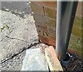
Ordnance Survey Cut Mark
This OS cut mark can be found on No39 Wolfs Castle Avenue. It marks a point 63.258m above mean sea level.
Image: © Adrian Dust
Taken: 26 Feb 2024
0.04 miles
2
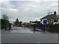
Llanishen High School
Entrance to Llanishen High School.
Image: © Alan Hughes
Taken: 15 Nov 2017
0.05 miles
3
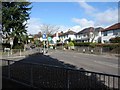
Heol Hir and Templeton Avenue Road junction
The entrance to Llanishen High School is on the right just off the photograph.
Image: © Roy Douglas
Taken: Unknown
0.08 miles
6
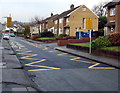
Zigzag yellow markings on Everest Avenue, Llanishen, Cardiff
Marking the Keep Clear zone near the entrance https://www.geograph.org.uk/photo/5631677 to Christ the King Roman Catholic primary school.
Signs show no stopping on the markings from 8am-4:30pm Mondays-Fridays.
Image: © Jaggery
Taken: 20 Dec 2017
0.21 miles
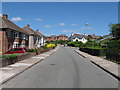
7
Everest Avenue semis, Llanishen, Cardiff
Semi-detached houses on the approach to the entrance https://www.geograph.org.uk/photo/5631677 to Christ the King Roman Catholic primary school.
Image: © Jaggery
Taken: 20 Dec 2017
0.22 miles
8
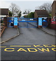
Entrance to Christ the King R C Primary School, Llanishen, Cardiff
Roman Catholic primary school entrance from Everest Avenue.
Image: © Jaggery
Taken: 20 Dec 2017
0.22 miles
9
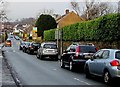
On-street parking, Everest Avenue, Llanishen, Cardiff
The distant large gap between parked cars is this https://www.geograph.org.uk/photo/5631693 Keep Clear zone near a school entrance.
Image: © Jaggery
Taken: 20 Dec 2017
0.22 miles
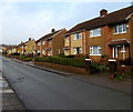
10
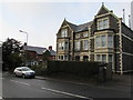
Stone semis in Llanishen, Cardiff
Two semi-detached stone houses viewed across the B4562 Station Road.
Image: © Jaggery
Taken: 20 Dec 2017
0.22 miles