IMAGES TAKEN NEAR TO
St. Malo Road, CARDIFF, CF14 4HL
Introduction
This page details the photographs taken nearby to St. Malo Road, CF14 4HL by members of the Geograph project.
The Geograph project started in 2005 with the aim of publishing, organising and preserving representative images for every square kilometre of Great Britain, Ireland and the Isle of Man.

There are currently over 7.5m images from over14,400 individuals and you can help contribute to the project by visiting https://www.geograph.org.uk
Image Map
Images are licensed for reuse under creativecommons.org/licenses/by-sa/2.0
Notes
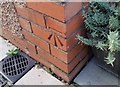
- Clicking on the map will re-center to the selected point.
- The higher the marker number, the further away the image location is from the centre of the postcode.
Image Listing (41 Images Found)
Images are licensed for reuse under creativecommons.org/licenses/by-sa/2.0
Image
Details
Distance
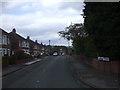
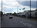
2
St Malo Rd, Heath Cardiff
Most of the streets in this area are called after "Saints". Those north of Heathwood Rd are almost all from the Celtic tradition (e.g.Image, Image),those to the south mostly from the Roman (e.g.Image, Image).
Image: © John Lord
Taken: 2 May 2010
0.04 miles
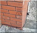
3
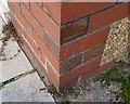
Ordnance Survey Cut Mark
This OS cut mark can be found on No49 St Ina Road. It marks a point 40.926m above mean sea level.
Image: © Adrian Dust
Taken: 18 Nov 2018
0.05 miles
4
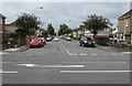
Northern end of Heathway, Cardiff
Looking south along Heathway from Maes-y-coed Road. Heathway extends for 630 metres to Heathwood Road.
Image: © Jaggery
Taken: 21 Jun 2016
0.09 miles
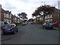
5
Maes-y-coed road, Cardiff
Maes-y-coed road, Birchgrove in Cardiff
Image: © Steve Chapple
Taken: 20 Aug 2005
0.10 miles
6
Ordnance Survey Cut Mark
This OS cut mark can be found on No79 Heath Way. It marks a point 38.198m above mean sea level.
Image: © Adrian Dust
Taken: 18 Nov 2018
0.11 miles
7
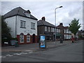
Post Office, surgery etc, St Isan Rd, Cardiff
Image: © John Lord
Taken: 2 May 2010
0.12 miles
8
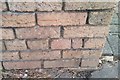
Ordnance Survey Cut Mark
This OS cut mark can be found on the wall of No102 Maes Y Coed Road. It marks a point 36.286m above mean sea level.
Image: © Adrian Dust
Taken: 18 Nov 2018
0.13 miles
9
Ordnance Survey Cut Mark
This OS cut mark can be found on No8 St Ina Road. It marks a point 39.011m above mean sea level.
Image: © Adrian Dust
Taken: 18 Nov 2018
0.13 miles
10
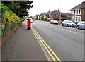
Pillarbox outside Tesco House, Cardiff
Alongside Maes-y-coed Road on the south side of Tesco House. http://www.geograph.org.uk/photo/5007258
The Queen Elizabeth II royal cipher is on the box.http://www.geograph.org.uk/photo/5007142
Image: © Jaggery
Taken: 21 Jun 2016
0.13 miles