1
Playing fields, Heath Park, Cardiff
The houses in the distance are on King George V Drive North. The building on the left edge of the photo is Cathay RFC's pavilion. http://www.geograph.org.uk/photo/1965672
Image: © Jaggery
Taken: 2 Oct 2009
0.04 miles
2
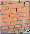
Ordnance Survey Cut Mark
This OS cut mark can be found on the wall of No165 Heathwood Road. It marks a point 39.959m above mean sea level.
Image: © Adrian Dust
Taken: 18 Nov 2018
0.05 miles
3
King George V Drive, Cardiff
The red sign reads: Cold calling control zone. What is done to control cold callers I don't know, nor why this area has been so designated.
Image: © John Lord
Taken: 3 May 2010
0.06 miles
4
St Gildas Rd, Heath, Cardiff
Image: © John Lord
Taken: 2 May 2010
0.09 miles
5
The Heathwood Rd oak tree
The eastern part of Heathwood Rd is lined with lime trees, the western part with London planes. Almost in the middle is this solitary oak, perhaps a survival from earlier times.
Image: © John Lord
Taken: 2 May 2010
0.09 miles
6
King George V Drive roundabout, Cardiff
At the end of a short connecting road from Heathwood Road, turn left for King George V Drive North or right via the roundabout for King George V Drive West.
Image: © Jaggery
Taken: 2 Oct 2009
0.10 miles
7
King George V Drive, Cardiff
Viewed from Heathwood Road.
Image: © Jaggery
Taken: 2 Oct 2009
0.10 miles
8
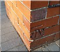
Ordnance Survey Cut Mark
This OS cut mark can be found on No115 Heathwood Road. It marks a point 38.121m above mean sea level.
Image: © Adrian Dust
Taken: 18 Nov 2018
0.11 miles
9
George V postbox, George V Drive West, Cardiff
Located a few metres from a roundabout. http://www.geograph.org.uk/photo/1965663
This is an appropriate postbox for the area.
Image: © Jaggery
Taken: 2 Oct 2009
0.13 miles
10
Cathays RFC pavilion, Heath Park, Cardiff
There are two signs on the front of the building.
On the first is "Cathays R.F.C" (rugby football club)
Below it, a sign states
"CATHAYS HIGH SCHOOL
THESE PLAYING FIELDS AND
PAVILION ARE FOR THE USE OF
CATHAYS HIGH SCHOOL AND
OTHER AUTHORISED PERSONS ONLY"
Image: © Jaggery
Taken: 2 Oct 2009
0.14 miles


