IMAGES TAKEN NEAR TO
St. Helens Road, CARDIFF, CF14 4AR
Introduction
This page details the photographs taken nearby to St. Helens Road, CF14 4AR by members of the Geograph project.
The Geograph project started in 2005 with the aim of publishing, organising and preserving representative images for every square kilometre of Great Britain, Ireland and the Isle of Man.

There are currently over 7.5m images from over14,400 individuals and you can help contribute to the project by visiting https://www.geograph.org.uk
Image Map
Images are licensed for reuse under creativecommons.org/licenses/by-sa/2.0
Notes
- Clicking on the map will re-center to the selected point.
- The higher the marker number, the further away the image location is from the centre of the postcode.
Image Listing (97 Images Found)
Images are licensed for reuse under creativecommons.org/licenses/by-sa/2.0
Image
Details
Distance
1
Rhydhelig Avenue, Cardiff
Houses on the north side of the avenue, viewed from the Caerphilly Road end.
Image: © Jaggery
Taken: 2 Oct 2009
0.03 miles
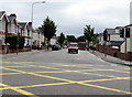
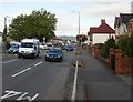
2
East along Lon-y-groes, Cardiff
Extending from the A470 Merthyr Road to the A469 Caerphilly Road (ahead).
Image: © Jaggery
Taken: 21 Jun 2016
0.06 miles
3
Adverts on a Caerphilly Road bus shelter, Cardiff
This is a Clear Channel advertising site.
Image: © Jaggery
Taken: 21 Jun 2016
0.06 miles
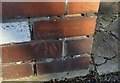
4
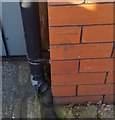
Ordnance Survey Cut Mark
This OS cut mark can be found on No35 Caerphilly Road. It marks a point 32.202m above mean sea level.
Image: © Adrian Dust
Taken: 18 Nov 2018
0.07 miles
5
Western end of Rhydhelig Avenue, Cardiff
Viewed across the A469 Caerphilly Road.
Image: © Jaggery
Taken: 21 Jun 2016
0.08 miles
6
Sweet Pea Daycare, Cardiff
Childcare (ages 6 months-5 years) at 64-66 Caerphilly Road, on the corner of Rhydhelig Avenue.
Image: © Jaggery
Taken: 21 Jun 2016
0.08 miles
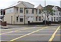
7
The New Inn, Birchgrove, Cardiff
Pub at 67 Caerphilly Road, on the corner of Hampton Road. Once known as The Chequers.
Image: © Jaggery
Taken: 19 Feb 2010
0.09 miles
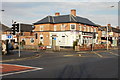
8
Cardiff : Caerphilly Road approaches North Road
To the right of the Aneurin Bevan, http://www.geograph.org.uk/photo/1715892 Caerphilly Road, heading south towards the camera, becomes North Road. Merthyr Road merges with North Road on the far side of the Aneurin Bevan.
Image: © Jaggery
Taken: 2 Oct 2009
0.09 miles
9
Ordnance Survey Cut Mark
This OS cut mark can be found on the gatepost between Nos39 & 41 Rhydhelig Avenue. It marks a point 32.717m above mean sea level.
Image: © Adrian Dust
Taken: 18 Nov 2018
0.09 miles