1
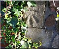
Ordnance Survey Cut Mark
This OS cut mark can be found at the wall angle of the cemetery. It marks a point 31.760m above mean sea level.
Image: © Adrian Dust
Taken: 19 Nov 2017
0.01 miles
2
Spar, Allensbank Road, Cardiff
Shop at 255-257 Allensbank Road, near the turning for Heath Mead.
Image: © Jaggery
Taken: 23 Aug 2010
0.02 miles
3
Corner of Heathwood Grove and Allensbank Road, Cardiff
Viewed across Allensbank Road. Heathwood Grove, a cul-de-sac, is the first residential street on the east side of Allensbank Road north of Cathays Cemetery.
Image: © Jaggery
Taken: 23 Aug 2010
0.02 miles
4
Allensbank Road
Image: © Fernweh
Taken: 23 Sep 2022
0.03 miles
5
Lane behind the houses
Back lane for the houses on King George V Drive and Allensbank Road.
Image: © Eirian Evans
Taken: 17 Jul 2010
0.04 miles
6
Ordnance Survey Cut Mark
This OS cut mark can be found on the gatepost at the entrance to No16 Allensbank Road. It marks a point 35.162m above mean sea level.
Image: © Adrian Dust
Taken: 19 Nov 2017
0.06 miles
7
Roundabout, Heath
At the junction of King George V Drive East with a short road less than 70 metres long linking it to Allenbanks Road. This is called "King George V Drive",
Image: © Derek Harper
Taken: 16 Jun 2018
0.07 miles
8
Highfields Day Centre, Cardiff
Located on Allensbank Road near the Highfield Road turning, this is a purpose-built centre for people with physical disabilities.
Image: © Jaggery
Taken: 23 Aug 2010
0.08 miles
9
Heath Citizens Association Hall, Cardiff
Adjacent to King George V Drive East. Among the many groups and societies using the hall are
Cardiff Scrabble Club
Cardiff Quilters
Cyncoed Floral Group
Honto Judo
India Dance Wales
Infocus Camera Club
Word of Life Fellowship Yoga
The Citizens Association also use a second hall http://www.geograph.org.uk/photo/1746096 a few metres behind this one.
Image: © Jaggery
Taken: 2 Oct 2009
0.09 miles
10
Heath Citizens Association building, Cardiff
This building is part of the Heath Citizens Association premises, set back a few metres from the main hall. http://www.geograph.org.uk/photo/1668819
Image: © Jaggery
Taken: 2 Oct 2009
0.09 miles


