IMAGES TAKEN NEAR TO
Nant Y Wedal, CARDIFF, CF14 3QU
Introduction
This page details the photographs taken nearby to Nant Y Wedal, CF14 3QU by members of the Geograph project.
The Geograph project started in 2005 with the aim of publishing, organising and preserving representative images for every square kilometre of Great Britain, Ireland and the Isle of Man.

There are currently over 7.5m images from over14,400 individuals and you can help contribute to the project by visiting https://www.geograph.org.uk
Image Map
Images are licensed for reuse under creativecommons.org/licenses/by-sa/2.0
Notes
- Clicking on the map will re-center to the selected point.
- The higher the marker number, the further away the image location is from the centre of the postcode.
Image Listing (60 Images Found)
Images are licensed for reuse under creativecommons.org/licenses/by-sa/2.0
Image
Details
Distance
1
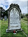
?The sad ending of a brave young life.?
125 years ago today the body of Louisa Maud Evans was washed ashore near Newport. An astonishing and tragic story which is told on this gravestone in Cathays Cemetery, Cardiff.
Image: © Alan Hughes
Taken: 6 Oct 2020
0.08 miles
2
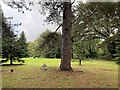
A graveyard without gravestones
The gravestones in the north western corner of Cathays cemetery were flattened by a bomb dropped during World War II. Nearby houses in Allensbank Road were also damaged during the raid which was targeting the Taff Vale railway line.
Image: © Alan Hughes
Taken: 6 Oct 2020
0.10 miles
3
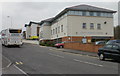
Crwys Medical Centre, Cardiff
Medical centre and pharmacy, opened in September 2005, located on the corner of Wedal Road and Allensbank Road. Previously, Crwys Medical Practice, established c1900, was at 151 Crwys Road.
The building is half in Ordnance Survey grid square ST1779 and half in square ST1879. http://www.geograph.org.uk/photo/1927735 to the view from the other square.
Image: © Jaggery
Taken: 14 Apr 2010
0.11 miles
5
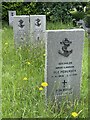
Patch of Norwegian War Graves at Cathays Cemetery
Alongside the Commonwealth war graves in this cemetery, the CWGC cares for those of 25 French sailors of the WW1, and one Dutch sailor and eight Norwegians of WW2.
The headstones shown bear a design agreed in consultation with Norwegian authorities and are made of Norwegian slate.
Three Norwegian merchant seamen killed on 2 January 1941 in Cardiff's worst air raid are buried at this site, the headstone for one of which (Ole Toresius Pedersen) is pictured.
Image: © Jakob Matera-Byford
Taken: 29 May 2024
0.13 miles
6
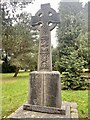
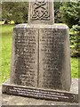
Irish famine memorial
Commemorating the Irish famine, 1845 - 1849.
See Image] for a close-up of the inscription.
Image: © Alan Hughes
Taken: 10 Nov 2022
0.13 miles
8
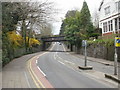
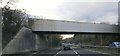
Wedal Road railway bridge, Cardiff
Viewed from the corner of Lake Road West, Wedal Road approaches a railway bridge,
headroom 13 feet (4 metres).
Image: © Jaggery
Taken: 14 Apr 2010
0.13 miles
9
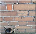
Ordnance Survey Cut Mark
This OS cut mark can be found on No2 Grasmere Avenue. It marks a point 22.830m above mean sea level.
Image: © Adrian Dust
Taken: 19 Nov 2017
0.16 miles
10
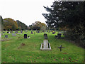
Cardiff Cemetery
This is the northern extension of the City cemetery, separated from the main cemetery to the south when Eastern Avenue was built.
Image: © Dylan Moore
Taken: 24 Nov 2016
0.16 miles