1
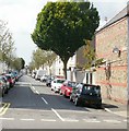
Inglefield Avenue, Cardiff
Looking west from Allensbank Road towards Summerfield Avenue.
Image: © Jaggery
Taken: 3 Sep 2009
0.03 miles
2
Clodien Avenue allotments, Cardiff
Viewed from Allensbank Road. The allotments are between Clodien Avenue and Eastern
Avenue.
Image: © Jaggery
Taken: 2 Oct 2009
0.03 miles
3
Access road, Cathays Cemetery, Cardiff
The road leads from Allensbank Road through the western side of Cathays Cemetery.
Opened in 1859, the cemetery occupies more than 100 acres on a site between Allensbank Road and Roath Park.
Image: © Jaggery
Taken: 3 Sep 2009
0.06 miles
4
Arjans cafe, Cardiff
Cafe with hot and cold food (eat in or take out) at 147 Clodien Road, adjacent to Allensbank House hall of residence. The round stones fixed to the pavement are presumably to stop parking.
Image: © Jaggery
Taken: 3 Sep 2009
0.06 miles
5
Grape and Olive,Cardiff
39 Wedal Road, Cardiff, at the Allensbank Road junction. They describe themselves as "one of Cardiff’s most exciting new drink and dining experiences, mixing contemporary style with modern Mediterranean cuisine and refreshing beers and wines"
Image: © Jaggery
Taken: 3 Sep 2009
0.06 miles
6
Ordnance Survey Cut Mark
This OS cut mark can be found on the wall between Nos31 & 33 Inglefield Avenue. It marks a point 28.764m above mean sea level.
Image: © Adrian Dust
Taken: 11 Nov 2017
0.06 miles
7
Ordnance Survey Cut Mark
This OS cut mark can be found on the gatepost at the entrance to Cathays Cemetery. It marks a point 28.203m above mean sea level.
Image: © Adrian Dust
Taken: 11 Nov 2017
0.08 miles
8
Summerfield Avenue, Cardiff
Viewed from Clodien Avenue looking towards Llanishen Street.
Image: © Jaggery
Taken: 3 Sep 2009
0.08 miles
9
Allensbank Primary School, Cardiff
Located on Llanishen Street. Built in 1905, the school currently has about 200 pupils enrolled.
School motto "Only our best will do"
Image: © Jaggery
Taken: 14 Apr 2010
0.09 miles
10
Ordnance Survey Cut Mark
This OS cut mark can be found on the dividing wall between Nos.47 & 49 Manor Street. It marks a point 29.163m above mean sea level.
Image: © Adrian Dust
Taken: 16 Mar 2018
0.10 miles


