IMAGES TAKEN NEAR TO
St. Marks Avenue, CARDIFF, CF14 3NW
Introduction
This page details the photographs taken nearby to St. Marks Avenue, CF14 3NW by members of the Geograph project.
The Geograph project started in 2005 with the aim of publishing, organising and preserving representative images for every square kilometre of Great Britain, Ireland and the Isle of Man.

There are currently over 7.5m images from over14,400 individuals and you can help contribute to the project by visiting https://www.geograph.org.uk
Image Map
Images are licensed for reuse under creativecommons.org/licenses/by-sa/2.0
Notes
- Clicking on the map will re-center to the selected point.
- The higher the marker number, the further away the image location is from the centre of the postcode.
Image Listing (65 Images Found)
Images are licensed for reuse under creativecommons.org/licenses/by-sa/2.0
Image
Details
Distance
2
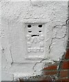
Ordnance Survey Flush Bracket (S1279)
This OS Flush Bracket can be found on No342 Whitchurch Road. It marks a point 29.727m above mean sea level.
Image: © Adrian Dust
Taken: 4 Mar 2024
0.04 miles
3
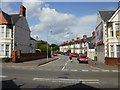
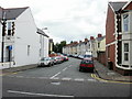
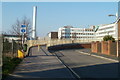
St Mark's Avenue, Cardiff
Viewed from the western end of Whitchurch Road.
St Mark's Avenue is a cul-de-sac ending at the boundary wall of Eastern Avenue (A48), close to the Gabalfa Interchange.
Image: © Jaggery
Taken: 3 Sep 2009
0.05 miles
4
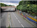
Public art on Eastern Avenue, Cardiff
Photograph taken from the footbridge/cycle bridge. The building in the background is the University Hospital of Wales (aka Heath Hospital).
Image: © John Lord
Taken: 1 Aug 2010
0.07 miles
5
Longspears Avenue, Cardiff
Viewed from Whitchurch Road.
Image: © Jaggery
Taken: 3 Sep 2009
0.07 miles
6
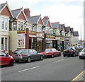
Pine Dungeon, Cardiff
Furniture shop at 308-312 Whitchurch Road.
Image: © Jaggery
Taken: 3 Sep 2009
0.07 miles
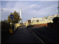
7
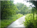
Footpath between the Gabalfa Interchange and Heath Hospital, Cardiff
Image: © John Lord
Taken: 8 Jul 2012
0.08 miles
8
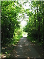
Footpath to Heath Hospital
Possibly the trackbed of the former Roath Docks branch.
Image: © Gareth James
Taken: 4 Jun 2010
0.09 miles
9
Dental school, hospital and chimney, Cardiff
Viewed from the northern edge of Flaxland Avenue. A footbridge across Eastern Avenue (A48) leads to a dental school and hospital, and to the University Hospital of Wales (often referred to as 'The Heath')
Image: © Jaggery
Taken: 23 Mar 2011
0.09 miles
10
Ramp to foot & cycle bridge over Eastern Avenue, Cardiff
University Hospital of Wales in the background
Image: © John Lord
Taken: 17 Nov 2011
0.10 miles