1
Gladstone Junior School
"Built 1899-1900 for the Cardiff School Board by E.W.M. Corbett ... Queen-Anne style 2-storey school of red St Julian brick with Hartham Park Bath stone dressings and slate roof with panelled brick stacks ... a prominent Board School now rare in retaining its original character" http://ishare.cardiff.gov.uk/Projects/Cadw/CardiffListedBuildings/25825.pdf .
Seen across the A469 Whitchurch Road.
Image: © Derek Harper
Taken: 16 Jun 2018
0.03 miles
2
St Michael and All Angels, Cardiff
Church located on the corner of Whitchurch Road and Gelligaer Street. It is in the parish of Cathays, diocese of Llandaff, in the Church in Wales, a sister church of the Church of England, and part of the worldwide Anglican Communion.
Image: © Jaggery
Taken: 15 Jul 2010
0.03 miles
3
Ordnance Survey Cut Mark
This OS cut mark can be found on an old cemetery gatepost NE side of the road.
Image: © Adrian Dust
Taken: 16 Mar 2018
0.03 miles
4
Cathays Library, Cardiff
A Carnegie library. A 10-month refurbishment has just been completed, including cleaning the stonework.
Image: © John Lord
Taken: 28 Jul 2010
0.06 miles
5
Cathays Library
On the corner between Whitchurch Road (left) and Fairoak Road. "Endowed by Andrew Carnegie and built in 1906-7 by Speir & Bevan ... The unusual butterfly plan echoes contemporary Arts and Crafts designs by E.S. Prior and W. Lethaby and is one of the earliest examples of such a plan form in Wales" http://ishare.cardiff.gov.uk/Projects/Cadw/CardiffListedBuildings/13681.pdf .
Image: © Derek Harper
Taken: 16 Jun 2018
0.06 miles
6
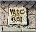
Old Boundary Marker by the A649, Whitchurch Road, Cardiff
Estate Boundary Marker - War Department by the A469, in parish of Cathays (Cardiff District), Whitchurch Road, set flat in pavement in front of shop, adjacent to military access road by War Memorial.
To be surveyed
Milestone Society National ID: GLA_WDCAT01em.
Image: © A Dust
Taken: Unknown
0.06 miles
7
Public toilets at the SE end of Whitchurch Road, Cardiff
The year 1934 is inscribed in stone on the building, which adjoins the NW edge of Cathays Library. http://www.geograph.org.uk/photo/1984259
Image: © Jaggery
Taken: 10 Apr 2011
0.06 miles
8
St Monica's Church in Wales School, Cardiff
Primary school located on the corner of Whitchurch Road and Pentyrch Street, adjacent to the crossroads with Crwys Road, Cathays Terrace and Fairoak Road.
Image: © Jaggery
Taken: 15 Jul 2010
0.06 miles
9
Gladstone Primary School and Nursery Unit, Cardiff
Located on Whitchurch Road near its southeast end at the edge of Crwys Road.
The building dates from 1900.
Image: © Jaggery
Taken: 15 Jul 2010
0.06 miles
10
Cathays Library
This is Cathays Library. Cathays Library is a Carnegie building opened in 1906 and is prominently situated on the junction of Cathays Terrace, Whitchurch Road, Fairoak Road and Crwys Road, next to Cathays Cemetery. It is a Grade 2 Listed building and contains several interesting architectural features
Image: © miriam
Taken: 27 Feb 2005
0.06 miles


