IMAGES TAKEN NEAR TO
Appledore Road, CARDIFF, CF14 3HW
Introduction
This page details the photographs taken nearby to Appledore Road, CF14 3HW by members of the Geograph project.
The Geograph project started in 2005 with the aim of publishing, organising and preserving representative images for every square kilometre of Great Britain, Ireland and the Isle of Man.

There are currently over 7.5m images from over14,400 individuals and you can help contribute to the project by visiting https://www.geograph.org.uk
Image Map
Images are licensed for reuse under creativecommons.org/licenses/by-sa/2.0
Notes
- Clicking on the map will re-center to the selected point.
- The higher the marker number, the further away the image location is from the centre of the postcode.
Image Listing (20 Images Found)
Images are licensed for reuse under creativecommons.org/licenses/by-sa/2.0
Image
Details
Distance
1
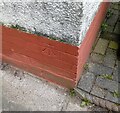
Ordnance Survey Cut Mark
This OS cut mark can be found on No180 Mynachdy Road. It marks a point 21.851m above mean sea level.
Image: © Adrian Dust
Taken: 4 Mar 2024
0.04 miles
2
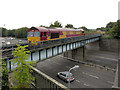
Railway at Maindy Bridge
An engineers' train from Westbury to Cardiff Queen Street via Stormstown Loop is seen crossing the A48 road at Maindy Bridge, with class 66 locomotive No. 66061 in charge.
Image: © Gareth James
Taken: 8 Oct 2016
0.16 miles
3
Railway bridge across Western Avenue, Cardiff
The bridge carries the Arriva Trains Wales route across Western Avenue. The next station on the route north is Llandaf, about 2 kilometres beyond the far end of the bridge.
Image: © Jaggery
Taken: 2 Oct 2009
0.17 miles
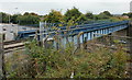
4
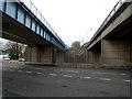
Two bridges over Western Avenue, Cardiff
The grey bridge connects Radyr Place and Mynachdy Road. The blue bridge http://www.geograph.org.uk/photo/1668742 behind it carries double-track railway lines on the Arriva Trains Wales Rhondda Line and Merthyr Line between Cathays station and Llandaf station.
Image: © Jaggery
Taken: 6 Jan 2012
0.17 miles
5
Between two bridges, Western Avenue, Cardiff
The grey bridge connects Radyr Place and Mynachdy Road.
The blue bridge http://www.geograph.org.uk/photo/1668742 carries double-track railway lines on the Arriva Trains Wales Rhondda Line and Merthyr Line between Cathays station and Llandaf station.
Image: © Jaggery
Taken: 6 Jan 2012
0.17 miles
6
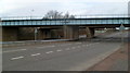
Railway bridge over Western Avenue, Cardiff
The bridge http://www.geograph.org.uk/photo/1668742 carries double-track railway lines on the Arriva Trains Wales Rhondda Line and Merthyr Line between Cathays station and Llandaf station. There is a road bridge http://www.geograph.org.uk/photo/2759064 behind the railway bridge.
Image: © Jaggery
Taken: 6 Jan 2012
0.17 miles
7
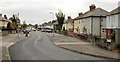
Mynachdy Road, Cardiff
Viewed from the Western Avenue end, heading towards North Road.
Image: © Jaggery
Taken: 2 Oct 2009
0.17 miles
8
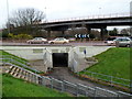
Subway under Gabalfa Interchange, Cardiff
One of several subways connecting footpaths under a major road junction at Gabalfa, to the north of Cardiff city centre.
Image: © Jaggery
Taken: 6 Jan 2012
0.17 miles
9
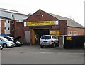
Three Horseshoes Garage, Cardiff
Located on Llwynderw Road, close to the Three Horse Shoes pub. http://www.geograph.org.uk/photo/1896037
The garage offers a wide range of services, including vehicle servicing, general repairs and specialist operations.
Image: © Jaggery
Taken: 2 Oct 2009
0.18 miles
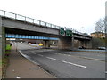
10
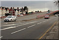
Gabalfa flyover, Cardiff
Looking along North Road towards the northern end of the Gabalfa Flyover, part of the Gabalfa Interchange.
The building of the Gabalfa Interchange in the late 1960s caused many changes in the area. Excavations were needed to form the new road linking Western Avenue and Eastern Avenue. Two bridges were built, as part of a roundabout controlling the traffic flow along five roads. A flyover provided a route carrying vehicles directly towards the city centre.
More than 100 houses and other buildings were demolished, among them the local library and the Regal dance hall. The most notable loss was St Mark the Evangelist church and vicarage. A final service was held in April 1968, whereupon worshippers moved to the new church http://www.geograph.org.uk/photo/1462652 nearby in North Road.
Image: © Jaggery
Taken: 19 Feb 2010
0.19 miles