1
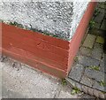
Ordnance Survey Cut Mark
This OS cut mark can be found on No180 Mynachdy Road. It marks a point 21.851m above mean sea level.
Image: © Adrian Dust
Taken: 4 Mar 2024
0.04 miles
2
Railway at Maindy Bridge
An engineers' train from Westbury to Cardiff Queen Street via Stormstown Loop is seen crossing the A48 road at Maindy Bridge, with class 66 locomotive No. 66061 in charge.
Image: © Gareth James
Taken: 8 Oct 2016
0.16 miles
3
Railway bridge across Western Avenue, Cardiff
The bridge carries the Arriva Trains Wales route across Western Avenue. The next station on the route north is Llandaf, about 2 kilometres beyond the far end of the bridge.
Image: © Jaggery
Taken: 2 Oct 2009
0.16 miles
4
Two bridges over Western Avenue, Cardiff
The grey bridge connects Radyr Place and Mynachdy Road. The blue bridge http://www.geograph.org.uk/photo/1668742 behind it carries double-track railway lines on the Arriva Trains Wales Rhondda Line and Merthyr Line between Cathays station and Llandaf station.
Image: © Jaggery
Taken: 6 Jan 2012
0.16 miles
5
Between two bridges, Western Avenue, Cardiff
The grey bridge connects Radyr Place and Mynachdy Road.
The blue bridge http://www.geograph.org.uk/photo/1668742 carries double-track railway lines on the Arriva Trains Wales Rhondda Line and Merthyr Line between Cathays station and Llandaf station.
Image: © Jaggery
Taken: 6 Jan 2012
0.16 miles
6
Railway bridge over Western Avenue, Cardiff
The bridge http://www.geograph.org.uk/photo/1668742 carries double-track railway lines on the Arriva Trains Wales Rhondda Line and Merthyr Line between Cathays station and Llandaf station. There is a road bridge http://www.geograph.org.uk/photo/2759064 behind the railway bridge.
Image: © Jaggery
Taken: 6 Jan 2012
0.16 miles
7
Mynachdy Road, Cardiff
Viewed from the Western Avenue end, heading towards North Road.
Image: © Jaggery
Taken: 2 Oct 2009
0.19 miles
8
Three Horseshoes Garage, Cardiff
Located on Llwynderw Road, close to the Three Horse Shoes pub. http://www.geograph.org.uk/photo/1896037
The garage offers a wide range of services, including vehicle servicing, general repairs and specialist operations.
Image: © Jaggery
Taken: 2 Oct 2009
0.22 miles
9
Subway under Gabalfa Interchange, Cardiff
One of several subways connecting footpaths under a major road junction at Gabalfa, to the north of Cardiff city centre.
Image: © Jaggery
Taken: 6 Jan 2012
0.22 miles
10
Staples superstore viewed from Western Avenue, Cardiff
The store occupies Unit B, Excelsior Industrial Estate, Batchelor Road.
The To Let sign refers to vacant units elsewhere, not this one.
Image: © Jaggery
Taken: 6 Jan 2012
0.22 miles


