1
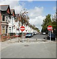
Canada Road, Cardiff
Viewed from near the North Road end, looking towards Africa Gardens.
Image: © Jaggery
Taken: 28 Aug 2009
0.03 miles
2
Africa Gardens, Gabalfa
This wide street is divided by an avenue of mature trees.
Image: © Eirian Evans
Taken: 1 Jun 2008
0.05 miles
3
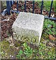
Old Boundary Marker by New Zealand Road, Gabalfa parish
Estate Boundary Marker - War Department by the UC road, in parish of Gabalfa (Cardiff District), New Zealand Road, in corner of two railings at start of footpath.
To be surveyed
Milestone Society National ID: GLA_WDGAB01em
Image: © Milestone Society
Taken: Unknown
0.06 miles
4
Ordnance Survey Cut Mark
This OS cut mark can be found on the dividing wall between Nos.3 & 5 Africa Gardens. It marks a point 30.486m above mean sea level.
Image: © Adrian Dust
Taken: 16 Mar 2018
0.07 miles
5
Houses on the east side of Parkfield Place, Cardiff
Looking towards North Road. The houses on this side are distinctly different from the semi-detached houses http://www.geograph.org.uk/photo/3056948 on the opposite side of the street. The two types of houses are separated by a tree-lined gap about 30 metres wide.
Image: © Jaggery
Taken: 28 Jul 2012
0.07 miles
6
New Zealand Road, Cardiff
The view from the North Road end, looking towards Whitchurch Road.
The trees on the east side of the road are on the perimeter of Cathays High School; further along on this side is the edge of government buildings (Companies House).
Image: © Jaggery
Taken: 28 Aug 2009
0.08 miles
7
New Zealand Road, Gabalfa
On the left of the street is Cathays High School.
Image: © Eirian Evans
Taken: 1 Jun 2008
0.08 miles
8
Cathays High School, Cardiff
On New Zealand Road, this is a mixed comprehensive school of about 1000 pupils. Shown here is the old entrance building.
Image: © Eirian Evans
Taken: 1 Jun 2008
0.08 miles
9
Ordnance Survey Cut Mark
This OS cut mark can be found on No49 Africa Gardens. It marks a point 31.888m above mean sea level.
Image: © Adrian Dust
Taken: 16 Mar 2018
0.09 miles
10
Parade of Shops - North Road - Cardiff
Image: © Anthony Parkes
Taken: 4 Apr 2016
0.09 miles


