1
Bobby's Shop, Llandaff North, Cardiff
Lifestyle Express convenience store at 30 Station Road.
Image: © Jaggery
Taken: 18 Apr 2016
0.00 miles
2
Clark's Pies van in Llandaff North, Cardiff
Making a pie delivery to Bobby's Shop http://www.geograph.org.uk/photo/4915961 at 30 Station Road. Clark's Pies, nicknamed Clarkies or Clarksies, are meat pies made in Cardiff. The exact recipe of the pie filling is a closely-guarded secret. Each pie has CLARPIE stamped into the pastry.The first Clark's Pies were made by Mary Clark in 1913.
Image: © Jaggery
Taken: 18 Apr 2016
0.01 miles
3
Station Road demolition site, Llandaff North, Cardiff
In mid April 2016, a Bond Demolition machine is at work in the former James & Jenkins garage site.
The business has relocated to the opposite side of the road. http://www.geograph.org.uk/photo/4917506
Image: © Jaggery
Taken: 18 Apr 2016
0.02 miles
4
Station Road, Llandaff North, Cardiff
Looking NNW along the A4054 Station Road in mid April 2016 when the
zebra crossing on a hump is newly installed. Black covers remain on the Belisha beacon globes.
Image: © Jaggery
Taken: 18 Apr 2016
0.02 miles
5
Demolition site entrance, Llandaff North, Cardiff
Viewed in mid April 2016. The Bond Demolition site was formerly the James & Jenkins car sales and vehicle hire site. The business has relocated to the opposite side of the road. http://www.geograph.org.uk/photo/4917506
Image: © Jaggery
Taken: 18 Apr 2016
0.02 miles
6
Ordnance Survey Cut Mark
This OS cut mark can be found on The Pineapple Inn, Station Road. It marks a point 20.690m above mean sea level.
Image: © Adrian Dust
Taken: 28 Oct 2019
0.03 miles
7
Former Charter Vehicle Hire, Llandaff North, Cardiff
Viewed across the A4054 Station Road in mid April 2016.
This is part of the former James & Jenkins car sales and vehicle hire site.
The business has relocated to the opposite side of the road. http://www.geograph.org.uk/photo/4917506
Image: © Jaggery
Taken: 18 Apr 2016
0.03 miles
8
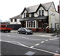
The Pineapple, Llandaff North, Cardiff
The Cardiff Pubs website states that the Pineapple at 39 Station Road was built around the start of the 20th century alongside a canal. The unusual name came from the regular barge cargo of pineapples.
http://www.geograph.org.uk/photo/4915967 to the faded name sign.
Image: © Jaggery
Taken: 18 Apr 2016
0.04 miles
9
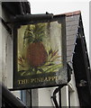
Pineapple pub name sign, Llandaff North, Cardiff
Faded in April 2016, the sign is on the wall above the car here. http://www.geograph.org.uk/photo/4915965
Image: © Jaggery
Taken: 18 Apr 2016
0.04 miles
10
Zebra crossing, Station Road, Llandaff North, Cardiff
Viewed from the corner of Maplewood Avenue in April 2016 when the crossing looks to have been recently installed. It is not shown on a Google Earth Street View taken seven months earlier.
Image: © Jaggery
Taken: 18 Apr 2016
0.04 miles


