IMAGES TAKEN NEAR TO
Kelston Road, CARDIFF, CF14 2AJ
Introduction
This page details the photographs taken nearby to Kelston Road, CF14 2AJ by members of the Geograph project.
The Geograph project started in 2005 with the aim of publishing, organising and preserving representative images for every square kilometre of Great Britain, Ireland and the Isle of Man.

There are currently over 7.5m images from over14,400 individuals and you can help contribute to the project by visiting https://www.geograph.org.uk
Image Map
Images are licensed for reuse under creativecommons.org/licenses/by-sa/2.0
Notes
- Clicking on the map will re-center to the selected point.
- The higher the marker number, the further away the image location is from the centre of the postcode.
Image Listing (75 Images Found)
Images are licensed for reuse under creativecommons.org/licenses/by-sa/2.0
Image
Details
Distance
1
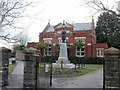
Whitchurch War Memorial, Cardiff
The war memorial is located at the entrance to Whitchurch Library, situated between Velindre Road and Park Road.
Image: © Jaggery
Taken: 19 Feb 2010
0.02 miles
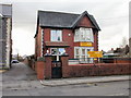
2
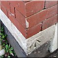
Ordnance Survey Cut Mark
This OS cut mark can be found on No29 Velindre Road. It marks a point 35.741m above mean sea level.
Image: © Adrian Dust
Taken: 18 Nov 2018
0.05 miles
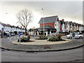
3
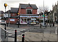
Cancer Research Wales shop, Whitchurch
Charity shop at 55 Penlline Road, adjacent to the roundabout junction of 5 roads in the centre of Whitchurch.
Image: © Jaggery
Taken: 19 Feb 2010
0.06 miles
4
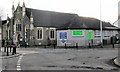
The Methodist Church, Whitchurch, Cardiff
Located on the corner of Penlline Road and Kelston Road. The church hall is on the right of the church.
Image: © Jaggery
Taken: 19 Feb 2010
0.06 miles
5
The Village Barbers, Whitchurch, Cardiff
At 1 Velindre Road, on the corner of Kelston Road (on the left).
Image: © Jaggery
Taken: 19 Feb 2010
0.06 miles
6

Natural Health and Fertility Clinic, Whitchurch, Cardiff
10 Penlline Road, Whitchurch.
The clinic focuses on women’s health and fertility. By integrating gynaecology with therapies such as acupuncture, reflexology and nutrition, the clinic offers a broad range of treatments for many conditions.
Image: © Jaggery
Taken: 19 Feb 2010
0.07 miles
7
Little Cherubs Day Nursery, Whitchurch, Cardiff
12 Penlline Rd, Whitchurch. Day nursery for children aged from 6 weeks to 5 years.
Image: © Jaggery
Taken: 19 Feb 2010
0.07 miles
8
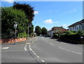
Kelston Road, Whitchurch, Cardiff
The A4054 Kelston Road viewed from the corner of Heol Don.
Image: © Jaggery
Taken: 10 Aug 2017
0.08 miles
9
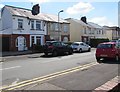
Velindre Place houses, Whitchurch, Cardiff
Viewed from the corner of Velindre Road.
Image: © Jaggery
Taken: 10 Aug 2017
0.08 miles
10
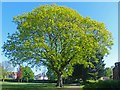
Oak tree, Whitchurch Library Park, Cardiff
A magnificent specimen situated just behind the library http://www.geograph.org.uk/photo/5388513 .
Image: © Robin Drayton
Taken: 8 May 2017
0.08 miles