1
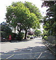
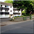
Bishop's Road houses, Whitchurch, Cardiff
Viewed from the corner of Wingfield Road.
Image: © Jaggery
Taken: 10 Aug 2017
0.01 miles
2
Bishop's Road, Whitchurch, Cardiff
The pillarbox is on the corner of Wingfield Road.
Image: © Jaggery
Taken: 10 Aug 2017
0.02 miles
3
Wingfield Road, Whitchurch, Cardiff
The red pillarbox is on the corner of Bishop's Road.
Image: © Jaggery
Taken: 10 Aug 2017
0.06 miles
4
King George V pillarbox, Wingfield Road, Whitchurch, Cardiff
Located here http://www.geograph.org.uk/photo/5492247 on the corner of Bishop's Road. The GR on the box is short for Georgius Rex,
Latin for King George, in this case King George V who reigned from May 1910-January 1936.
Image: © Jaggery
Taken: 10 Aug 2017
0.06 miles
5
Western end of Church Road, Whitchurch, Cardiff
Viewed across the A4054 Heol Don. Near a Virgin Media van, an engineer is working at a telecoms cabinet.
Image: © Jaggery
Taken: 10 Aug 2017
0.07 miles
6
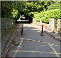
Metal posts at the western end of Wingfield Road, Whitchurch, Cardiff
Blocking the passage to the A4054 Heol Don of any vehicle wider than a motorbike.
Image: © Jaggery
Taken: 10 Aug 2017
0.08 miles
7
Firwood Close, Whitchurch, Cardiff
Cul-de-sac on the east side of the A4054 Heol Don.
Image: © Jaggery
Taken: 10 Aug 2017
0.08 miles
8
Telecoms cabinets near Heol Don Court, Whitchurch, Cardiff
Viewed across the A4054 Heol Don. A Virgin Media cabinet and
a BT cabinet are alongside the perimeter wall of Heol Don Court. http://www.geograph.org.uk/photo/5492315
Image: © Jaggery
Taken: 10 Aug 2017
0.09 miles
9
Ordnance Survey Cut Mark
This OS cut mark can be found on the wall of Benton House. It marks a point 30.593m above mean sea level.
Image: © Adrian Dust
Taken: 28 Oct 2019
0.09 miles
10
Ordnance Survey Flush Bracket (G3710)
This OS Flush Bracket can be found on the west parapet of the Railway Bridge, Station Road. It marks a point 29.455m above mean sea level.
Image: © Adrian Dust
Taken: 28 Oct 2019
0.09 miles


