IMAGES TAKEN NEAR TO
Sunnybank Close, CARDIFF, CF14 1EQ
Introduction
This page details the photographs taken nearby to Sunnybank Close, CF14 1EQ by members of the Geograph project.
The Geograph project started in 2005 with the aim of publishing, organising and preserving representative images for every square kilometre of Great Britain, Ireland and the Isle of Man.

There are currently over 7.5m images from over14,400 individuals and you can help contribute to the project by visiting https://www.geograph.org.uk
Image Map
Images are licensed for reuse under creativecommons.org/licenses/by-sa/2.0
Notes
- Clicking on the map will re-center to the selected point.
- The higher the marker number, the further away the image location is from the centre of the postcode.
Image Listing (24 Images Found)
Images are licensed for reuse under creativecommons.org/licenses/by-sa/2.0
Image
Details
Distance
1
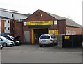
Three Horseshoes Garage, Cardiff
Located on Llwynderw Road, close to the Three Horse Shoes pub. http://www.geograph.org.uk/photo/1896037
The garage offers a wide range of services, including vehicle servicing, general repairs and specialist operations.
Image: © Jaggery
Taken: 2 Oct 2009
0.08 miles
2
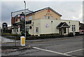
The Three Horse Shoes, Birchgrove, Cardiff
Pub on the corner of Merthyr Road and Llwynderw Road, opposite the Aneurin Bevan. http://www.geograph.org.uk/photo/1715892
Image: © Jaggery
Taken: 19 Feb 2010
0.11 miles
3
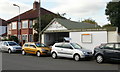
Apollo Cars, Cardiff
Used car dealer in premises located on the corner of Llwynderw Road and Merthyr Road, opposite the Three Horse Shoes pub .http://www.geograph.org.uk/photo/1896037
Image: © Jaggery
Taken: 2 Oct 2009
0.11 miles
4
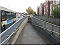
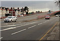
Ramp and stairs to underpass beneath North Road, Cardiff
A ramp and stairs lead down from the west side of North Road to an underpass below this artery from the city centre. A few metres to the north of this point,(behind the camera) North Road splits into Caerphilly Road and Merthyr Road.
On the left, a Cardiff Bus single-decker is on route 24 from the central bus station to Llandaff North via Whitchurch.
Image: © Jaggery
Taken: 2 Oct 2009
0.14 miles
5

Corner of Wauntreoda Rd and Heol-y-Gors, Cardiff
Image: © John Lord
Taken: 28 May 2011
0.14 miles
6
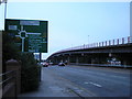
Gabalfa flyover, Cardiff
Looking along North Road towards the northern end of the Gabalfa Flyover, part of the Gabalfa Interchange.
The building of the Gabalfa Interchange in the late 1960s caused many changes in the area. Excavations were needed to form the new road linking Western Avenue and Eastern Avenue. Two bridges were built, as part of a roundabout controlling the traffic flow along five roads. A flyover provided a route carrying vehicles directly towards the city centre.
More than 100 houses and other buildings were demolished, among them the local library and the Regal dance hall. The most notable loss was St Mark the Evangelist church and vicarage. A final service was held in April 1968, whereupon worshippers moved to the new church http://www.geograph.org.uk/photo/1462652 nearby in North Road.
Image: © Jaggery
Taken: 19 Feb 2010
0.14 miles
7
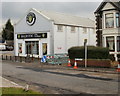
Majestic Wine Warehouse, The Philog, Cardiff
Wine shop located on the corner of The Philog and the A470.
Image: © Jaggery
Taken: 19 Feb 2010
0.14 miles
8
Gabalfa flyover, Cardiff
Gabalfa flyover, Mynachdy, Cardiff looking towards the city centre.
Image: © Steve Chapple
Taken: 18 Aug 2005
0.15 miles
10
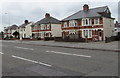
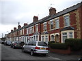
Merthyr Road semis, Cardiff
Semi-detached houses viewed across the A470 Merthyr Road from the corner of Lon-y-groes.
Image: © Jaggery
Taken: 21 Jun 2016
0.16 miles