IMAGES TAKEN NEAR TO
Coedydafarn, CARDIFF, CF14 0RQ
Introduction
This page details the photographs taken nearby to Coedydafarn, CF14 0RQ by members of the Geograph project.
The Geograph project started in 2005 with the aim of publishing, organising and preserving representative images for every square kilometre of Great Britain, Ireland and the Isle of Man.

There are currently over 7.5m images from over14,400 individuals and you can help contribute to the project by visiting https://www.geograph.org.uk
Image Map
Images are licensed for reuse under creativecommons.org/licenses/by-sa/2.0
Notes
- Clicking on the map will re-center to the selected point.
- The higher the marker number, the further away the image location is from the centre of the postcode.
Image Listing (46 Images Found)
Images are licensed for reuse under creativecommons.org/licenses/by-sa/2.0
Image
Details
Distance
1
Church Close, Lisvane, Cardiff
Cul-de-sac on the west side of Church Road. Signs indicate no motor vehicles except for access.
Image: © Jaggery
Taken: 12 Jan 2018
0.07 miles
2
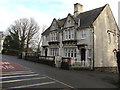
Two Grade II listed semi-detached houses, Lisvane Road, Lisvane, Cardiff
Dated 1931, the two houses named Carn Ingli and Cerrig Llwyd were each Grade II listed in 2000.
The Cadw website records that the houses were listed for their architectural interest as an exceptional pair of Portland stone houses built by the famous Cardiff builders E Turner and Sons in the interwar period.
Image: © Jaggery
Taken: 12 Jan 2018
0.09 miles
3
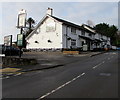
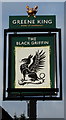
Black Griffin Inn, Church Road, Lisvane, Cardiff
A Greene King Local Pub. https://www.geograph.org.uk/photo/5650649 to the name sign on the left.
Image: © Jaggery
Taken: 12 Jan 2018
0.09 miles
4
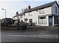
Old Post Office on a Lisvane corner, Cardiff
On the corner of Lisvane Road and Church Road. A sealed Victorian postbox https://www.geograph.org.uk/photo/5658017 is in the wall.
Image: © Jaggery
Taken: 12 Jan 2018
0.09 miles
5
Black Griffin name sign, Church Road, Lisvane, Cardiff
Located here. https://www.geograph.org.uk/photo/5650648 The Shorter Oxford English Dictionary defines a griffin as
"a mythical creature usually represented as having the head and wings of an eagle and the body of a lion".
Image: © Jaggery
Taken: 12 Jan 2018
0.10 miles
6
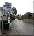
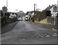
Warning sign - No footway for ? mile, Lisvane Road, Lisvane, Cardiff
The text on the sign alongside the B4562 Lisvane Road is also in Welsh.
Ahead for the Llanishen area of Cardiff and Cardiff city centre.
Image: © Jaggery
Taken: 12 Jan 2018
0.10 miles
7
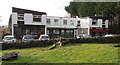
Church Road businesses, Lisvane, Cardiff
Names in view in mid January 2018 are H2O Hair Studio, Lisvane Store, Kelvin Francis Residential Sales.
Image: © Jaggery
Taken: 12 Jan 2018
0.10 miles
8
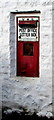
Victorian postbox in a Lisvane wall, Cardiff
The sealed former Post Office letter box is in the wall of this https://www.geograph.org.uk/photo/5658007 former post office.
Image: © Jaggery
Taken: 12 Jan 2018
0.10 miles
9
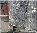
Ordnance Survey Cut Mark
This OS cut mark can be found on the tower of St Denis Church. It marks a point 79.422m above mean sea level.
Image: © Adrian Dust
Taken: 4 Mar 2024
0.10 miles
10
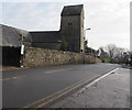
South along Church Road, Lisvane, Cardiff
Grade II (star) listed Parish Church of St Denys https://www.geograph.org.uk/photo/5658032 is on the left.
The Black Griffin Inn https://www.geograph.org.uk/photo/5650648 is out of shot on the right.
Image: © Jaggery
Taken: 12 Jan 2018
0.10 miles