1
Four bungalows, Fidlas Road, Cardiff
Located on the east side of the road, a little north of the turning for Three Arches Avenue.
Image: © Jaggery
Taken: 23 Aug 2010
0.06 miles
2
Footpath leading to railway underpass, Llanishen
Image: © Gareth James
Taken: 12 Jun 2010
0.07 miles
3
Ewenny Road, Cardiff
Houses on the south side of Ewenny Road, viewed from the Fidlas Road end.
Image: © Jaggery
Taken: 23 Aug 2010
0.07 miles
4
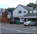
Llanishen Garage, Cardiff
Located at 83 Fidlas Road. Services advertised on the sign are MoT test centre, servicing, engine diagnostics, welding.
Image: © Jaggery
Taken: 23 Aug 2010
0.10 miles
5
Rail-head treatment train near Heath
A rail-head treatment train is seen in action as it descends between Llanishen and Heath High Level station with class 66 No. 66183 in charge.
Image: © Gareth James
Taken: 3 Dec 2020
0.12 miles
6
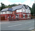
Cardiff : Fidlas Road houses north of Ewenny Road
Houses on the west side of the road, viewed from the corner of Ewenny Road. http://www.geograph.org.uk/photo/2030339
Image: © Jaggery
Taken: 23 Aug 2010
0.15 miles
7
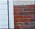
Ordnance Survey Cut Mark
This OS cut mark can be found on No23 Fidlas Road. It marks a point 36.771m above mean sea level.
Image: © Adrian Dust
Taken: 26 Feb 2024
0.16 miles
8
Corner of Fidlas Avenue and Fidlas Road, Cardiff
The southern edge of Fidlas Avenue viewed across Fidlas Road. The central part of Fidlas Avenue follows a course parallel with Fidlas Road, which it rejoins about 350 metres north of this point.
Image: © Jaggery
Taken: 23 Aug 2010
0.18 miles
9
Fidlas Avenue, Cardiff
Viewed across Fidlas Road. Ahead, Fidlas Avenue turns through 90 degrees and follows a course parallel with Fidlas Road, which it rejoins about 350 metres north of this corner.
Image: © Jaggery
Taken: 23 Aug 2010
0.19 miles
10
Llanishen Evangelical Church, Cardiff
In 1953 an evangelist Stan Ford held a gospel campaign in a large tent where the church now stands. The tent remained on the site after this, and a Sunday School and other meetings were held in it until it blew down in a gale. In 1954 a metal hut, dismantled from a site in Bedlinog, was erected here and a church was commenced, its opening service being on Sat. 15th May. The present brick-built chapel was opened on 7th March 1959, and an extension added in 1976. The church was originally called Llanishen Gospel Hall, then Emmaus Chapel, before the present name.
Image: © John Lord
Taken: 26 Aug 2008
0.19 miles


