1
Royal Mail sorting office, Penarth Road - Cardiff
Image: © Mick Lobb
Taken: 29 Jun 2009
0.04 miles
2
Poeton, Cardiff
Poeton Industries Ltd is a group of surface coating contracting companies which has operated since 1898. Their premises seen here are at 283 Penarth Road, Cardiff.
Image: © Jaggery
Taken: 5 Aug 2010
0.08 miles
3
Graffiti by the A4160
Some colour on the Penarth Road near Kismet Park.
Image: © Derek Harper
Taken: 15 Jun 2018
0.09 miles
4
Car showrooms, Penarth Road
The A4160 passes Wessex Kia and Hyundai, with Honda on the right, as it approaches the lights at the junction with Hadfield Road / Fleetway.
Image: © Derek Harper
Taken: 15 Jun 2018
0.09 miles
5
Works, Penarth Road
Looking across the A4160 to a surface coating works. On the left is a vehicle servicing garage.
Image: © Derek Harper
Taken: 15 Jun 2018
0.09 miles
6
Wessex Garages, Cardiff
Located at 289 Penarth Road, opposite the head post office. http://www.geograph.org.uk/photo/1378143
Main dealers for Kia, Fiat, Abarth and Nissan. Several hundred used cars are also for sale.
Image: © Jaggery
Taken: 5 Aug 2010
0.10 miles
7
Sloper Road, Cardiff
Sloper Road heads away from Penarth Road. Just out of shot on the left is a large
Halfords store. http://www.geograph.org.uk/photo/2046863
Image: © Jaggery
Taken: 5 Aug 2010
0.11 miles
8
Glynstell Close, Leckwith
Leading from Hadfield Road into Glynstell Park, formerly Glynstell Industrial Estate, now undergoing refurbishment. Viewed past a bank of tutsan.
Image: © Derek Harper
Taken: 15 Jun 2018
0.13 miles
9
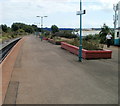
Island platform, Grangetown, Cardiff
The northbound and southbound tracks at Grangetown railway station are separated by one platform in the middle. Most 2-track railway stations have a platform on each side, with the tracks in the middle.
http://www.geograph.org.uk/photo/2047313 to a closeup view and description of the mobile phone mast at the right edge.
Image: © Jaggery
Taken: 5 Aug 2010
0.14 miles
10
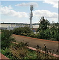
Mobile phone mast, Grangetown, Cardiff
Viewed from Grangetown railway station. The 12.7 metre high mast, owned by Orange,
has two transmitters, one transmitting at a frequency range of 1800 megahertz and the other at 2100 megahertz. Technically, these are macrocells. A macrocell provides the main coverage in a mobile network. The antennas for macrocells are mounted on ground-based masts, rooftops and other existing structures. They must be positioned at a height that is not obstructed by surrounding buildings and terrain. Macrocell base stations have a typical power output of tens of watts.
Image: © Jaggery
Taken: 5 Aug 2010
0.14 miles


