IMAGES TAKEN NEAR TO
Clive Street, CARDIFF, CF11 7HL
Introduction
This page details the photographs taken nearby to Clive Street, CF11 7HL by members of the Geograph project.
The Geograph project started in 2005 with the aim of publishing, organising and preserving representative images for every square kilometre of Great Britain, Ireland and the Isle of Man.

There are currently over 7.5m images from over14,400 individuals and you can help contribute to the project by visiting https://www.geograph.org.uk
Image Map
Images are licensed for reuse under creativecommons.org/licenses/by-sa/2.0
Notes
- Clicking on the map will re-center to the selected point.
- The higher the marker number, the further away the image location is from the centre of the postcode.
Image Listing (114 Images Found)
Images are licensed for reuse under creativecommons.org/licenses/by-sa/2.0
Image
Details
Distance
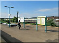
2
Access alleyway at the rear of Pentrebane St, Cardiff
Image: © John Lord
Taken: 24 Feb 2011
0.05 miles
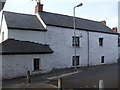
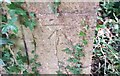
3
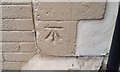
Ordnance Survey Cut Mark
This OS cut mark can be found on the NW face of No50 Clive Street. It marks a point 7.486m above mean sea level.
Image: © Adrian Dust
Taken: 1 Oct 2017
0.07 miles
4
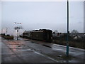
Bittern at Grangetown
Ex-LNER A4 60019 Bittern runs tender-first through Grangetown station, while on its turning manoeuvre.
Image: © Gareth James
Taken: 5 Dec 2009
0.08 miles
5
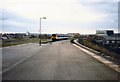
"Sprinter" Near Grangetown Station, 1988
A Class 150/2 "Sprinter" diesel multiple unit leaves Grangetown station in the spring of 1988
Image: © Rob Newman
Taken: 12 Mar 1988
0.08 miles
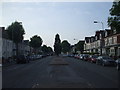
6
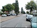
Clive Street, Cardiff
Viewed from near the Penarth Road end, looking to the SSE.
Image: © Jaggery
Taken: 5 Aug 2010
0.09 miles
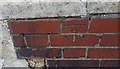
7
Ordnance Survey Cut Mark
This OS cut mark can be found on the NW face St Paul's Church. It marks a point 7.568m above mean sea level.
Image: © Adrian Dust
Taken: 1 Oct 2017
0.10 miles
8
Ordnance Survey Cut Mark
This OS cut mark can be found on the south face of the No83 Paget Street. It marks a point 7.315m above mean sea level.
Image: © Adrian Dust
Taken: 1 Oct 2017
0.10 miles