IMAGES TAKEN NEAR TO
Corporation Road, CARDIFF, CF11 7AQ
Introduction
This page details the photographs taken nearby to Corporation Road, CF11 7AQ by members of the Geograph project.
The Geograph project started in 2005 with the aim of publishing, organising and preserving representative images for every square kilometre of Great Britain, Ireland and the Isle of Man.

There are currently over 7.5m images from over14,400 individuals and you can help contribute to the project by visiting https://www.geograph.org.uk
Image Map
Images are licensed for reuse under creativecommons.org/licenses/by-sa/2.0
Notes
- Clicking on the map will re-center to the selected point.
- The higher the marker number, the further away the image location is from the centre of the postcode.
Image Listing (108 Images Found)
Images are licensed for reuse under creativecommons.org/licenses/by-sa/2.0
Image
Details
Distance
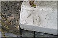
2
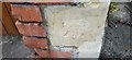
Ordnance Survey Cut Mark
This damaged OS cut mark can be found on the SE face of No21 Clydach Street. It marks a point 8.126m above mean sea level.
Image: © Adrian Dust
Taken: 1 Oct 2017
0.04 miles
4
Ordnance Survey Cut Mark
This damaged OS cut mark can be found on the SE face of No71 Corporation Road. It marks a point 8.202m above mean sea level.
Image: © Adrian Dust
Taken: 1 Oct 2017
0.05 miles
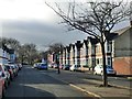
5
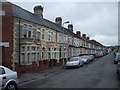
Terraced houses, Penhevad St, Cardiff
The first three houses have unusually ornate stonework above the bay windows
Image: © John Lord
Taken: 19 May 2010
0.05 miles
6
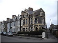
Terraced houses, Pentrebane St, Cardiff
The acute-angled junction of street and lane leaves space for a separate porch for the end house.
Image: © John Lord
Taken: 24 Feb 2011
0.06 miles
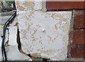
8
Ordnance Survey Pivot
This OS pivot can be found on the wall of No79 Pentre Bane Street. It marks a point 7.324m above mean sea level.
Image: © Adrian Dust
Taken: 1 Oct 2017
0.08 miles
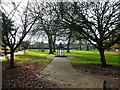
10
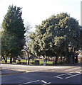
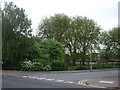
Northeast corner of Grange Gardens, Grangetown, Cardiff
This corner of the park is bordered by Corporation Road and Holmesdale Street.
Grange Gardens is a small Victorian park in Grangetown. The land was given to Cardiff Corporation in 1892 by Lord Windsor and Lord Bute. It was officially opened on June 19th 1895 and still has something of a Victorian character.
Image: © Jaggery
Taken: 5 Feb 2010
0.08 miles