IMAGES TAKEN NEAR TO
Allerton Street, CARDIFF, CF11 6SJ
Introduction
This page details the photographs taken nearby to Allerton Street, CF11 6SJ by members of the Geograph project.
The Geograph project started in 2005 with the aim of publishing, organising and preserving representative images for every square kilometre of Great Britain, Ireland and the Isle of Man.

There are currently over 7.5m images from over14,400 individuals and you can help contribute to the project by visiting https://www.geograph.org.uk
Image Map
Images are licensed for reuse under creativecommons.org/licenses/by-sa/2.0
Notes
- Clicking on the map will re-center to the selected point.
- The higher the marker number, the further away the image location is from the centre of the postcode.
Image Listing (180 Images Found)
Images are licensed for reuse under creativecommons.org/licenses/by-sa/2.0
Image
Details
Distance
1
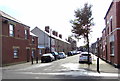
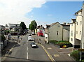
SE along Allerton Street, Grangetown, Cardiff
This part of Allerton Street is on the southeast side of Court Road.
Ahead are Cornwall Street and Clare Road.
Image: © Jaggery
Taken: 17 Sep 2017
0.03 miles
2
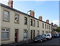
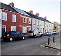
Court Road houses, Grangetown, Cardiff
This part of Court Road is near the Monmouth Street junction, out of shot on the right.
Image: © Jaggery
Taken: 17 Sep 2017
0.04 miles
3
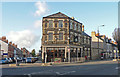
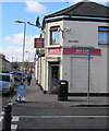
The Neville - Cardiff
On the junction of Clare Road and Cornwall Street.
Image: © Mick Lobb
Taken: 3 Dec 2009
0.04 miles
4
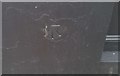
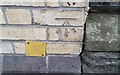
Ordnance Survey Cut Mark
This OS cut mark can be found on the south face of the shop, once the Neville Hotel. It marks a point 7.736m above mean sea level.
Image: © Adrian Dust
Taken: 1 Oct 2017
0.04 miles
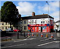
5
Mas & Co corner shop, 58 Court Road, Grangetown, Cardiff
On the corner of Court Road and Jubilee Street.
Image: © Jaggery
Taken: 17 Sep 2017
0.05 miles
6
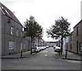
Sussex Street, Grangetown, Cardiff
From Court Road along Sussex Street towards Cornwall Street.
Image: © Jaggery
Taken: 17 Sep 2017
0.05 miles
7
Ordnance Survey Cut Mark
This OS cut mark can be found on the west face of No31 Clare Road. It marks a point 7.855m above mean sea level.
Image: © Adrian Dust
Taken: 1 Oct 2017
0.06 miles
8
Clare Road European Super Store, Cardiff
The convenience store & off licence is on the corner of Clare Road and Court Road. Text on the nameboard in September 2017 includes UK - INTERNATIONAL - POLAND - LITHUANIA - LATVIA - CZECH REPUBLIC. OPEN 7 DAYS A WEEK.
Image: © Jaggery
Taken: 17 Sep 2017
0.06 miles
9
Cardiff, Clare Road passing under railway line
Image: © Roy Hughes
Taken: 8 Jul 2021
0.06 miles
10
Court Road houses, Grangetown, Cardiff
Between Sussex Street and Stafford Road.
Image: © Jaggery
Taken: 17 Sep 2017
0.07 miles