1
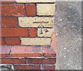
Ordnance Survey Cut Mark
This OS cut mark can be found on the west face of No1 Maitland Place. It marks a point 7.565m above mean sea level.
Image: © Adrian Dust
Taken: 1 Oct 2017
0.01 miles
2
Saltmead Presbyterian Church, Maitland Place, Cardiff
This church building was erected in 1992 after the demolition of its 90 year old Edwardian predecessor.
Image: © Jaggery
Taken: 17 Sep 2017
0.04 miles
3
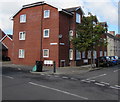
Saltmead Court, Grangetown, Cardiff
The Maitland Place side of flats on the corner of Hereford Street.
Image: © Jaggery
Taken: 17 Sep 2017
0.05 miles
4
Saltmead Court, Grangetown, Cardiff
Three-storey block of flats on the corner of Maitland Place and Hereford Street.
Image: © Jaggery
Taken: 17 Sep 2017
0.05 miles
5
Metal posts between Hereford Street and Court Road, Grangetown, Cardiff
Hereford Street is on the left.
Image: © Jaggery
Taken: 17 Sep 2017
0.05 miles
6
Masala Bazaar, Powderham Drive, Cardiff
Shop viewed from the corner of Virgil Street.
Image: © Jaggery
Taken: 17 Sep 2017
0.07 miles
7
Powderham Drive, Cardiff
Viewed from near the corner of Virgil Street, this is the southeast part of Powderham Drive,
a dead-end road extending for 600 metres to the edge of railway lines near Cardiff Canton Depot.
Image: © Jaggery
Taken: 17 Sep 2017
0.07 miles
8
Virgil Street railway bridge, Grangetown, Cardiff
Headroom shown is 13' 6".
Image: © Jaggery
Taken: 17 Sep 2017
0.08 miles
9
Ordnance Survey Cut Mark
This OS cut mark can be found on the SE face of the Railway Bridge. It marks a point 7.315m above mean sea level.
Image: © Adrian Dust
Taken: 1 Oct 2017
0.08 miles
10
Rutland Street, Grangetown, Cardiff
Looking towards Hereford Street.
Image: © Jaggery
Taken: 17 Sep 2017
0.08 miles


