1
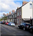
Court Road houses, Grangetown, Cardiff
This part of Court Road is near the Monmouth Street junction, out of shot on the right.
Image: © Jaggery
Taken: 17 Sep 2017
0.01 miles
2
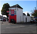
Clare Road European Super Store, Cardiff
The convenience store & off licence is on the corner of Clare Road and Court Road. Text on the nameboard in September 2017 includes UK - INTERNATIONAL - POLAND - LITHUANIA - LATVIA - CZECH REPUBLIC. OPEN 7 DAYS A WEEK.
Image: © Jaggery
Taken: 17 Sep 2017
0.03 miles
3
Cardiff, Clare Road passing under railway line
Image: © Roy Hughes
Taken: 8 Jul 2021
0.03 miles
4
Clare Road European Super Store in Grangetown, Cardiff
The Court Road side of the shop on the corner of Clare Road. http://www.geograph.org.uk/photo/5618028
Image: © Jaggery
Taken: 17 Sep 2017
0.03 miles
5
Alexandra Dock 2-6-2T at Cardiff Canton Locomotive Depot
One of two ex-Alexandra Docks Railways 2-6-2Ts that survived into Nationalisation, No. 1205 (built 1920, withdrawn 1/56).
Image: © Ben Brooksbank
Taken: 15 Apr 1951
0.04 miles
6
Monmouth Street houses, Grangetown, Cardiff
From the corner of Court Road.
Image: © Jaggery
Taken: 17 Sep 2017
0.04 miles
7
Clare Road flats, Cardiff
On the west side of the A4119 Clare Road near Court Road and Pendyris Street.
Image: © Jaggery
Taken: 17 Sep 2017
0.04 miles
8
Ordnance Survey Cut Mark
This OS cut mark can be found on the west face of No31 Clare Road. It marks a point 7.855m above mean sea level.
Image: © Adrian Dust
Taken: 1 Oct 2017
0.05 miles
9
Nashville Hot advert, Clare Road, Cardiff
The KFC advert is on a Primesight board alongside the A4119 Clare Road on September 17th 2017.
Image: © Jaggery
Taken: 17 Sep 2017
0.05 miles
10
South side of Clare Road railway bridge, Cardiff
Extending for 45 metres away from the camera, the bridge carries many railway lines over the A4119 Clare Road. The headroom warning sign on the bridge shows 15' 6"
Image: © Jaggery
Taken: 17 Sep 2017
0.05 miles


