IMAGES TAKEN NEAR TO
Pentre Gardens, CARDIFF, CF11 6QG
Introduction
This page details the photographs taken nearby to Pentre Gardens, CF11 6QG by members of the Geograph project.
The Geograph project started in 2005 with the aim of publishing, organising and preserving representative images for every square kilometre of Great Britain, Ireland and the Isle of Man.

There are currently over 7.5m images from over14,400 individuals and you can help contribute to the project by visiting https://www.geograph.org.uk
Image Map
Images are licensed for reuse under creativecommons.org/licenses/by-sa/2.0
Notes
- Clicking on the map will re-center to the selected point.
- The higher the marker number, the further away the image location is from the centre of the postcode.
Image Listing (411 Images Found)
Images are licensed for reuse under creativecommons.org/licenses/by-sa/2.0
Image
Details
Distance
1
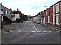
West along Pentre Gardens, Cardiff
From Taffs Mead Embankment looking along the street named Pentre Gardens towards Universal Street.
Image: © Jaggery
Taken: 14 Sep 2017
0.01 miles
2
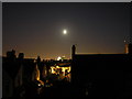
Looking towards town on a summer's night
Taken from my loft towards this grid ref
Image: © Steve Chapple
Taken: 16 Jul 2005
0.03 miles
4
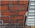
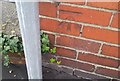
Ordnance Survey Cut Mark
This OS cut mark can be found on the south face of the garage at the rear of No46 Taffs Mead Embankment. It marks a point 7.894m above mean sea level.
Image: © Adrian Dust
Taken: 1 Oct 2017
0.03 miles
5
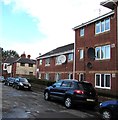
Flats and satellite dishes, Pentre Place, Cardiff
Part of Skomer Court viewed from the corner of Penarth Road.
Image: © Jaggery
Taken: 14 Sep 2017
0.06 miles
6
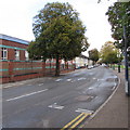
Temporary signs on Taffs Mead Embankment, Cardiff
On Sunday September 17th 2017, signs showing ROAD AHEAD CLOSED and RESIDENTS ACCESS ONLY are on the Taffs Mead Embankment roadway near the corner of Pentre Gardens.
Image: © Jaggery
Taken: 17 Sep 2017
0.06 miles
7
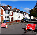
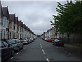
North along Taffs Mead Embankment, Cardiff
Taffs Mead Embankment is a street on the west bank of the River Taff.
Image: © Jaggery
Taken: 14 Sep 2017
0.06 miles
8
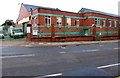
Track 2000 Community Warehouse, Cardiff
Located in Resource House on the corner of Penarth Road and Taffs Mead Embankment.
The name sign shows Track 2000 Community Warehouse - Re-use/New Furniture of All Types.
Image: © Jaggery
Taken: 14 Sep 2017
0.06 miles
9
Ordnance Survey Cut Mark
This OS cut mark can be found on the west face of No23 Merches Gardens. It marks a point 7.867m above mean sea level.
Image: © Adrian Dust
Taken: 1 Oct 2017
0.06 miles
10
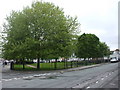
Mardy St, Grangetown, Cardiff, looking north
At the far end can be seen Cardiff Council's Central Workshops (See Image)
Image: © John Lord
Taken: 19 May 2010
0.07 miles