IMAGES TAKEN NEAR TO
North Clive Street, CARDIFF, CF11 6NS
Introduction
This page details the photographs taken nearby to North Clive Street, CF11 6NS by members of the Geograph project.
The Geograph project started in 2005 with the aim of publishing, organising and preserving representative images for every square kilometre of Great Britain, Ireland and the Isle of Man.

There are currently over 7.5m images from over14,400 individuals and you can help contribute to the project by visiting https://www.geograph.org.uk
Image Map
Images are licensed for reuse under creativecommons.org/licenses/by-sa/2.0
Notes
- Clicking on the map will re-center to the selected point.
- The higher the marker number, the further away the image location is from the centre of the postcode.
Image Listing (179 Images Found)
Images are licensed for reuse under creativecommons.org/licenses/by-sa/2.0
Image
Details
Distance
1
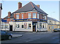
The Cornwall, Grangetown, Cardiff
Pub on the corner of Hereford Street and Cornwall Street. The name of the pub might simply be from its location on Cornwall Street, but the pub sign shows a sailing ship, mostly likely the 19th-century Royal Navy ship HMS Cornwall.
Image: © Jaggery
Taken: 5 Feb 2010
0.02 miles
2
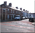
Tynant Street, Grangetown, Cardiff
From Virgil Street along Tynant Street towards Rookwood Street.
Image: © Jaggery
Taken: 17 Sep 2017
0.04 miles
3
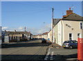
North Clive Street, Grangetown
Looking north along North Clive Street from the Bishop Street junction.
Image: © Jaggery
Taken: 5 Feb 2010
0.04 miles
4
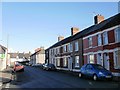
Rookwood Street,Grangetown
Viewed from the corner of Tynant Street.
Image: © Jaggery
Taken: 5 Feb 2010
0.04 miles
5
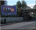
Virgil Street advert for NOW TV, Grangetown, Cardiff
The Primesight advertising board is near this http://www.geograph.org.uk/photo/5540825 railway bridge.
Image: © Jaggery
Taken: 17 Sep 2017
0.05 miles
6
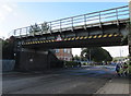
Virgil Street railway bridge, Grangetown, Cardiff
Headroom shown is 13' 6".
Image: © Jaggery
Taken: 17 Sep 2017
0.06 miles
7
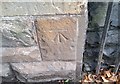
Ordnance Survey Cut Mark
This OS cut mark can be found on the SE face of the Railway Bridge. It marks a point 7.315m above mean sea level.
Image: © Adrian Dust
Taken: 1 Oct 2017
0.06 miles
8
Hereford Street towards Cornwall Street, Grangetown, Cardiff
Courtmead Community Gardens are on the left.
Image: © Jaggery
Taken: 17 Sep 2017
0.06 miles
9
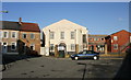
St Patrick's Parish Hall, Grangetown
Located at the end of Bishop Street, at the bend into Lucknow Street.
Image: © Jaggery
Taken: 5 Feb 2010
0.07 miles
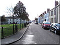
10
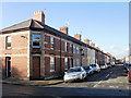
Tynant Street, Grangetown, Cardiff
Houses on the west side of Tynant Street viewed from Rookwood Street.
Image: © Jaggery
Taken: 5 Feb 2010
0.07 miles