IMAGES TAKEN NEAR TO
Grangemoor Court, CARDIFF, CF11 0AD
Introduction
This page details the photographs taken nearby to Grangemoor Court, CF11 0AD by members of the Geograph project.
The Geograph project started in 2005 with the aim of publishing, organising and preserving representative images for every square kilometre of Great Britain, Ireland and the Isle of Man.

There are currently over 7.5m images from over14,400 individuals and you can help contribute to the project by visiting https://www.geograph.org.uk
Image Map
Images are licensed for reuse under creativecommons.org/licenses/by-sa/2.0
Notes
- Clicking on the map will re-center to the selected point.
- The higher the marker number, the further away the image location is from the centre of the postcode.
Image Listing (13 Images Found)
Images are licensed for reuse under creativecommons.org/licenses/by-sa/2.0
Image
Details
Distance
1

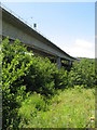
Ice Arena Wales
An ice hockey rink opened in 2016 which is currently sponsored by a financial services company. The rink is the home of the Cardiff Devils Ice Hockey Club
Image: © Graham Hogg
Taken: 8 Mar 2020
0.13 miles
3
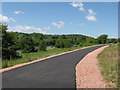
Ely Trail, Cardiff
Near the start of the Ely Trail: cyclepath and footpath
Image: © Gareth James
Taken: 20 Jun 2010
0.16 miles
5
Cardiff Trade Sales
Cardiff Trade Sales, Penarth Road.
Image: © Alan Hughes
Taken: 27 Feb 2017
0.17 miles
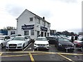
7
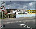
Penarth Road Snooker Centre
Viewed from the corner of Llandough Hill.
Snooker and pool are available. The centre has a licensed bar, with hot snacks.
Image: © Jaggery
Taken: 5 Aug 2010
0.18 miles
8
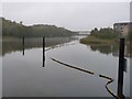
Boom on the River Ely / Afon Elai
At the mouth of a 'bay' on the east bank. Immediately north of a large estate of flats, on Watkiss Way. This river was tidal here before Cardiff Bay barrage was built.
Image: © Christine Johnstone
Taken: 12 Nov 2016
0.19 miles
9
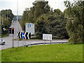
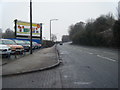
Grangetown Link Road
Slip road from the A4055 to the A4232 (Grangetown Link Road).
Image: © David Dixon
Taken: 28 Aug 2012
0.21 miles
10
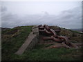
The summit of Penarth Moors
Would one call this a sculpture? A feature?
Image: © John Lord
Taken: 30 Nov 2011
0.22 miles