IMAGES TAKEN NEAR TO
Hodges Square, CARDIFF, CF10 5JT
Introduction
This page details the photographs taken nearby to Hodges Square, CF10 5JT by members of the Geograph project.
The Geograph project started in 2005 with the aim of publishing, organising and preserving representative images for every square kilometre of Great Britain, Ireland and the Isle of Man.

There are currently over 7.5m images from over14,400 individuals and you can help contribute to the project by visiting https://www.geograph.org.uk
Image Map
Images are licensed for reuse under creativecommons.org/licenses/by-sa/2.0
Notes
- Clicking on the map will re-center to the selected point.
- The higher the marker number, the further away the image location is from the centre of the postcode.
Image Listing (143 Images Found)
Images are licensed for reuse under creativecommons.org/licenses/by-sa/2.0
Image
Details
Distance
1
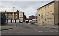
Hodges Row, Butetown, Cardiff
Cul-de-sac viewed across Bute Street.
Image: © Jaggery
Taken: 20 Nov 2019
0.02 miles
2
Churches working together banner, Butetown, Cardiff
The banner is here https://www.geograph.org.uk/photo/6325142 above the entrance to Loudoun Square Methodist Church, also known as St Paul's Community Church. The banner text is in English and Welsh
Image: © Jaggery
Taken: 20 Nov 2019
0.03 miles
3
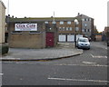
Click Cafe, Bute Street, Cardiff
Internet cafe on the corner of Bute Street and Hodges Row.
Image: © Jaggery
Taken: 24 Oct 2009
0.03 miles
4
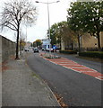
One-sided Bute Street, Cardiff
As far south as Cardiff Bay railway station, http://www.geograph.org.uk/photo/1967282 Bute Street is very much one-sided in that the houses and shops are all on the west side of the street. On the east side, a wall separates the street from the railway line from Cardiff Queen Street to Cardiff Bay. The monotony of the wall is broken only occasionally by paths leading, under railway bridges, to Lloyd George Avenue.
Image: © Jaggery
Taken: 24 Oct 2009
0.03 miles
5
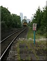
Train approaching Cardiff Bay
A Cardiff Queen Street to Cardiff Bay train approaches its destination.
Image: © Richard Sutcliffe
Taken: 8 Jun 2016
0.03 miles
6
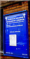
Information board for a church with two names, Butetown, Cardiff
The board on the wall here https://www.geograph.org.uk/photo/6325142 shows that Loudoun Square Methodist Church is also known as St Pauls Community Church. In November 2019 Sunday morning worship begins at 11 o'clock.
Image: © Jaggery
Taken: 20 Nov 2019
0.03 miles
7
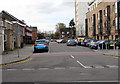
West along South Loudoun Place, Butetown, Cardiff
From Bute Street along South Loudoun Place towards Loudoun Square.
This is part of the area known (especially formerly) as Tiger Bay.
Its usual modern name is Cardiff Bay.
Image: © Jaggery
Taken: 20 Nov 2019
0.03 miles
8
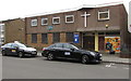
Taxis parked outside a church, South Loudoun Place, Butetown, Cardiff
Loudoun Square Methodist Church, also known as St Pauls Community Church, is part of the Cardiff Methodist Circuit.
Image: © Jaggery
Taken: 20 Nov 2019
0.04 miles
9
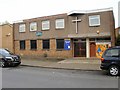
Loudoun Square Methodist Church, Cardiff
Located a few metres from the junction with Bute Street.
Image: © Jaggery
Taken: 24 Oct 2009
0.04 miles
10
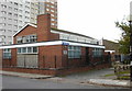
Butetown Health Centre, Cardiff
Located on Loudoun Square, opposite the Methodist church. http://www.geograph.org.uk/photo/1966088
Image: © Jaggery
Taken: 24 Oct 2009
0.04 miles