IMAGES TAKEN NEAR TO
Waverley Square, CARDIFF, CF10 5GQ
Introduction
This page details the photographs taken nearby to Waverley Square, CF10 5GQ by members of the Geograph project.
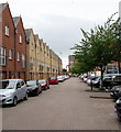
The Geograph project started in 2005 with the aim of publishing, organising and preserving representative images for every square kilometre of Great Britain, Ireland and the Isle of Man.

There are currently over 7.5m images from over14,400 individuals and you can help contribute to the project by visiting https://www.geograph.org.uk
Image Map
Images are licensed for reuse under creativecommons.org/licenses/by-sa/2.0
Notes
- Clicking on the map will re-center to the selected point.
- The higher the marker number, the further away the image location is from the centre of the postcode.
Image Listing (221 Images Found)
Images are licensed for reuse under creativecommons.org/licenses/by-sa/2.0
Image
Details
Distance
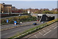
1
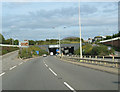
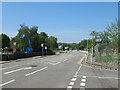
West Portal of the Bute Town Tunnel
The curved roof centre right is the Wales Millennium Centre.
Image: © John Thorn
Taken: 18 Sep 2006
0.01 miles
2
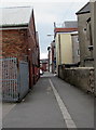
Harrowby Lane, Cardiff
From Hunter Street along Harrowby Lane towards Harrowby Place.
Image: © Jaggery
Taken: 10 Jun 2017
0.03 miles
3
Docks Conservative Club
Private members Club in Hunter Street.
Image: © Alan Hughes
Taken: 26 May 2017
0.05 miles
4
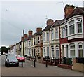
Hunter Street houses, Cardiff
Looking to the SW along Hunter Street from near the corner of Burt Street.
Image: © Jaggery
Taken: 10 Jun 2017
0.05 miles
5
Harrowby Street, Cardiff
Dead-end street on the south side of James Street.
A nearby name sign shows that Harrowby Street leads to Burt Place.
Image: © Jaggery
Taken: 10 Jun 2017
0.06 miles
6
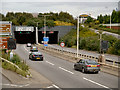
Tunnel Under Butetown
The A4232 goes underground as it reaches Cardiff city centre.
Image: © David Dixon
Taken: 28 Aug 2012
0.06 miles
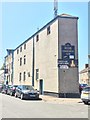
7
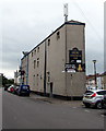
Docks Conservative Club, Cardiff
Located in a triangular building at 11 Hunter Street, on the corner of Burt Street (on the left).
Image: © Jaggery
Taken: 10 Jun 2017
0.06 miles
9
Ordnance Survey Cut Mark
This OS cut mark can be found on Hunter Lofts, Hunter Street. It marks a point 9.251m above mean sea level.
Image: © Adrian Dust
Taken: 3 Feb 2019
0.07 miles
10
Cardiff : The A4232 & Queen's Gate
The road heads underneath the tunnel at Queen's Gate.
Image: © Lewis Clarke
Taken: 30 Mar 2014
0.08 miles