IMAGES TAKEN NEAR TO
West Bute Street, CARDIFF, CF10 5GL
Introduction
This page details the photographs taken nearby to West Bute Street, CF10 5GL by members of the Geograph project.
The Geograph project started in 2005 with the aim of publishing, organising and preserving representative images for every square kilometre of Great Britain, Ireland and the Isle of Man.

There are currently over 7.5m images from over14,400 individuals and you can help contribute to the project by visiting https://www.geograph.org.uk
Image Map
Images are licensed for reuse under creativecommons.org/licenses/by-sa/2.0
Notes
- Clicking on the map will re-center to the selected point.
- The higher the marker number, the further away the image location is from the centre of the postcode.
Image Listing (753 Images Found)
Images are licensed for reuse under creativecommons.org/licenses/by-sa/2.0
Image
Details
Distance
1
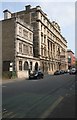
Cory's Building, Bute Street
Grade II listed commercial building on Bute Street, built in 1889 for the Cory Brothers Ltd.
Image: © Richard Sutcliffe
Taken: 6 Jun 2016
0.01 miles
3
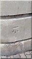
Ordnance Survey Cut Mark
This OS cut mark can be found on the south angle of the Cambrian Buildings, West Bute Street. It marks a point 7.172m above mean sea level.
Image: © Adrian Dust
Taken: 3 Feb 2019
0.03 miles
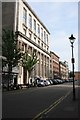
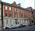
4

Pascoe House
This lovely High Victorian building was erected in 1875 with the three bay extension added in 1906. Originally built for the Powell Duffryn Coal Company, the building is listed, grade II, with details at: http://cadwpublic-api.azurewebsites.net/reports/listedbuilding/FullReport?lang=en&id=13964
Image: © Michael Dibb
Taken: 11 Dec 2016
0.03 miles
6
Kemis Cafe Bar, Cardiff
Cafe and bar at the southern end of Lloyd George Avenue. In the same building, Craft in the Bay is the permanent exhibition venue for contemporary applied art and craft, used by members of The Makers' Guild in Wales.
Image: © Jaggery
Taken: 24 Oct 2009
0.03 miles
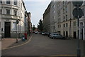
7
Bute Street
The neglected building on the left is the original Taff Vale Railway's Cardiff Docks station dating from 1840.
Image: © Richard Sutcliffe
Taken: 6 Jun 2016
0.04 miles
8
Cardiff - Butetown
Some buildings in Cardiff's Bay have survived WW2 bombing and have been renovated as the area goes upmarket.
Image: © Colin Smith
Taken: 1 Apr 2015
0.05 miles
9
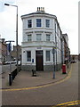
RBS, Cardiff Docks
Royal Bank of Scotland branch, 125 Bute Street, occupying part of a narrow island between Bute Street (on the left) and West Bute Street.
Despite the area now being known generally as Cardiff Bay, the branch retains its Cardiff Docks name.
Image: © Jaggery
Taken: 24 Oct 2009
0.06 miles
10
Meandros House, Cardiff Bay
One of several Grade II listing buildings in the area, this is Meandros House, 54A Bute Street.
Now in use as office buildings, it was formerly the offices of a ship stores company.
Image: © Jaggery
Taken: 24 Oct 2009
0.06 miles