1
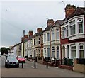
Houses in Clarence Embankment, Cardiff
The older house, with the sign, has an elaborate pediment to the front door
Image: © David Smith
Taken: 19 Sep 2022
0.01 miles
2
Viewing area
This small viewing area on the River Taff is seen from Clarence Embankment.
Image: © Michael Dibb
Taken: 11 Dec 2016
0.02 miles
3
Ordnance Survey Cut Mark
This OS cut mark can be found on No13 Clarence Embankment. It marks a point 8.784m above mean sea level.
Image: © Adrian Dust
Taken: 3 Feb 2019
0.03 miles
4
Clarence House, former base of Salvage Association
Image: © David Smith
Taken: 19 Sep 2022
0.04 miles
5
Across Clarence Road Bridge, Cardiff
The bridge which opened in 1976 carries the A4119 over the River Taff. The river here is about 60 metres wide.
Image: © Jaggery
Taken: 10 Jun 2017
0.05 miles
6
The River Taff from Clarence Road
Cardiff Bay is just around the next bend.
Image: © Bill Boaden
Taken: 31 Mar 2013
0.05 miles
7
Clarence Bridge, Cardiff, 1966
The occasion was a special tour over former trolleybus routes in the Grangetown area of the City, which had closed at short notice when a weight restriction was imposed on the bridge at Wood Street. Cardiff's trolleybuses, when assessed with a full passenger load, exceeded the limit, requiring replacement by motor buses. Before the wiring was de-energised and removed, permission was granted to run a special tour including those routes, with the proviso that passengers would have to disembark for the crossing of Wood Street Bridge.
This is not the bridge in question, but the much more interesting Clarence Bridge linking Grangetown with Bute Town. It was designed by Borough Engineer William Harpur and opened in September 1890 by the Duke of Clarence. It was replaced by a modern bridge in the early 1970s.
Image: © Alan Murray-Rust
Taken: 20 Mar 1966
0.05 miles
8
River Taff, Clarence Road Bridge
The bridge carrying Clarence Road (the A4119) over the River Taff at Cardiff.
Image: © David Dixon
Taken: 28 Aug 2012
0.05 miles
9
Hunter Street houses, Cardiff
Looking to the SW along Hunter Street from near the corner of Burt Street.
Image: © Jaggery
Taken: 10 Jun 2017
0.06 miles
10
Clarence House, Clarence Rd, Cardiff
A reminder of Cardiff's maritime heritage, the inscription on the building is Salvage Association, London.
Image: © John Lord
Taken: 19 May 2010
0.06 miles


