IMAGES TAKEN NEAR TO
Heol Staughton, CARDIFF, CF10 5FS
Introduction
This page details the photographs taken nearby to Heol Staughton, CF10 5FS by members of the Geograph project.
The Geograph project started in 2005 with the aim of publishing, organising and preserving representative images for every square kilometre of Great Britain, Ireland and the Isle of Man.

There are currently over 7.5m images from over14,400 individuals and you can help contribute to the project by visiting https://www.geograph.org.uk
Image Map
Images are licensed for reuse under creativecommons.org/licenses/by-sa/2.0
Notes
- Clicking on the map will re-center to the selected point.
- The higher the marker number, the further away the image location is from the centre of the postcode.
Image Listing (128 Images Found)
Images are licensed for reuse under creativecommons.org/licenses/by-sa/2.0
Image
Details
Distance
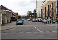
1
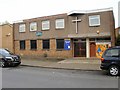
Loudoun Square Methodist Church, Cardiff
Located a few metres from the junction with Bute Street.
Image: © Jaggery
Taken: 24 Oct 2009
0.06 miles
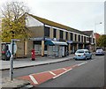
2
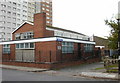
Butetown Health Centre, Cardiff
Located on Loudoun Square, opposite the Methodist church. http://www.geograph.org.uk/photo/1966088
Image: © Jaggery
Taken: 24 Oct 2009
0.06 miles
3
Paddle Steamer pub - Loudoun Square
Location used in Doctor Who series - note the Tardis has been swapped for a red wheelie bin!
Image: © Chris Edwards
Taken: 18 Feb 2006
0.07 miles
4

Hannah Street towards a minaret, Butetown, Cardiff
The minaret is part of the South Wales Islamic Centre in Alice Street.
Image: © Jaggery
Taken: 20 Nov 2019
0.09 miles
5
Towards Loudoun House, Butetown, Cardiff
From Bute Street along South Loudoun Place towards 16-storey Loudoun House in Loudoun Square. The multistorey building was erected in 1963-1964. It contains 120 flats.
Image: © Jaggery
Taken: 20 Nov 2019
0.11 miles
6
West along South Loudoun Place, Butetown, Cardiff
From Bute Street along South Loudoun Place towards Loudoun Square.
This is part of the area known (especially formerly) as Tiger Bay.
Its usual modern name is Cardiff Bay.
Image: © Jaggery
Taken: 20 Nov 2019
0.11 miles
7
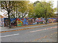
Butetown mural, Cardiff
Located on the west side of Bute Street, close to an area of shops http://www.geograph.org.uk/photo/1966074 near the southern end of the street.
Image: © Jaggery
Taken: 24 Oct 2009
0.11 miles
8
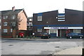
Bute Street Minimarket, Cardiff
Newsagent, tobacconists, off-licence and store, part of an L-shaped area of shops on the west side of Bute Street.
Image: © Jaggery
Taken: 24 Oct 2009
0.11 miles
9
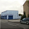
Brandon Tool Hire, Butetown,Cardiff
The distinctive two-tone blue makes Brandon Tool Hire premises recognisable long before the name is readable. This one is on the corner of Bute Street and Hannah Street.
Image: © Jaggery
Taken: 24 Oct 2009
0.11 miles
10
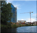
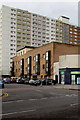
Housing development at Century Wharf
Due for completion 2007/2008 - viewed from the waterbus.
Image: © Pauline E
Taken: 22 Jul 2007
0.12 miles