IMAGES TAKEN NEAR TO
North Church Street, CARDIFF, CF10 5EJ
Introduction
This page details the photographs taken nearby to North Church Street, CF10 5EJ by members of the Geograph project.
The Geograph project started in 2005 with the aim of publishing, organising and preserving representative images for every square kilometre of Great Britain, Ireland and the Isle of Man.

There are currently over 7.5m images from over14,400 individuals and you can help contribute to the project by visiting https://www.geograph.org.uk
Image Map
Images are licensed for reuse under creativecommons.org/licenses/by-sa/2.0
Notes
- Clicking on the map will re-center to the selected point.
- The higher the marker number, the further away the image location is from the centre of the postcode.
Image Listing (255 Images Found)
Images are licensed for reuse under creativecommons.org/licenses/by-sa/2.0
Image
Details
Distance
1
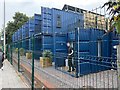
Cargo House Bute Street Containers
Cargo House is an innovative housing project consisting of 13 one and two bedroom apartments built from repurposed shipping containers.
https://www.cadwyn.co.uk/project/cargo-house-bute-street-containers/
Image: © Alan Hughes
Taken: 10 Aug 2020
0.01 miles
2

Parish church
The parish church of St Mary the Virgin and St Stephen the Martyr was built in 1843 to replace a medieval church. The church is unusual that the apparent main front of the building, seen here from Bute Street, is actually the rear with the front entrance facing west so as to preserve traditional liturgical orientation. Listed, grade II, with details at: http://cadwpublic-api.azurewebsites.net/reports/listedbuilding/FullReport?lang=en&id=13981
Image: © Michael Dibb
Taken: 11 Dec 2016
0.03 miles
3
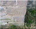
Ordnance Survey Cut Mark
This OS cut mark can be found on the NE face of St Mary's Church. It marks a point 8.101m above mean sea level.
Image: © Adrian Dust
Taken: 3 Feb 2019
0.03 miles
4
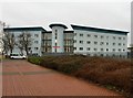
Ty Gobaith
Salvation Army hostel - serving the community.
Jeff:
i stayed at this hostel for 9 months . i was encouraged in every way to get my life back together .it took time but was encouraged even when i slipped into old habits the staff were there for me . now my life is amazing . the best it has ever been . happiness is a amazing feeling i never want to give away only share . God is blessing this hostel for sure .
Image: © Alan Hughes
Taken: 19 Feb 2016
0.04 miles
5
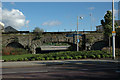
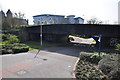
Bridge over Link Canal to Bute Docks
The link canal between the Glamorganshire Canal and the Bute Docks passed through the central arch of the rail bridge.
Bute Street (in the foreground) also bridged the link canal but was lowered after the canal closed in 1952.
Image: © Guy Butler-Madden
Taken: 1 Nov 2005
0.05 miles
6
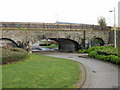
Cardiff : Path & Bridge
The path heads underneath the railway bridge.
Image: © Lewis Clarke
Taken: 30 Mar 2014
0.05 miles
7
Cardiff : Footpath from Bute Street to Lloyd George Avenue
On its way to Lloyd George Avenue, a footpath heads away from Bute Street towards a railway bridge.
Image: © Jaggery
Taken: 24 Oct 2009
0.05 miles
8
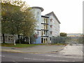
Ty Gobaith, Bute Street, Cardiff
Ty Gobaith is a Salvation Army Social Services Centre located near the northern end of Bute Street.
Image: © Jaggery
Taken: 24 Oct 2009
0.05 miles
9
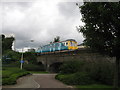
Cardiff Bay shuttle
The shuttle from Cardiff Bay makes its way back to Cardiff Queen Street, crossing the bridge that once spanned the Junction Canal linking Bute docks to the Glamorgan canal. It now spans a cycle/foot path linking Bute Street and Lloyd George Avenue.
Image: © Gareth James
Taken: 17 Aug 2009
0.06 miles
10
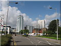
Northern end of Bute Street
Looking towards the various new developments in Cardiff City Centre
Image: © Gareth James
Taken: 28 Aug 2009
0.07 miles