1
North Road entrance to Bute Park, Cardiff
Bute Park is Cardiff's biggest city centre public park. It was created as the private garden to Cardiff Castle between 1873 and 1901 by head gardener Andrew Pettigrew for the third Marquess of Bute.
In 1947, a large part of the grounds was given to the people of Cardiff by the fifth Marquess of Bute, along with Cardiff Castle and Sophia Gardens. Further portions of land were bought and leased by the council to create an extensive park. The Victorian garden layout still exists, though since 1947 the park has been extensively planted with trees to form the Bute Park Arboretum.
Image: © Jaggery
Taken: 26 May 2014
0.02 miles
2
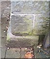
Ordnance Survey Cut Mark
This OS cut mark can be found on the gatepost of the Park. It marks a point 13.349m above mean sea level.
Image: © Adrian Dust
Taken: 1 Oct 2017
0.02 miles
3
Underpass, North Road
Steps lead down to the underpass under North Road. Capital Tower is in the distance.
Image: © Richard Sutcliffe
Taken: 12 Feb 2016
0.03 miles
4
A gate in the fence near Cardiff civic centre
Another security barrier in the distance in Boulevard de Nantes.
Image: © John Lord
Taken: 22 Aug 2014
0.03 miles
5
Cardiff : North Road A470
Looking along North Road in the centre of Cardiff.
Image: © Lewis Clarke
Taken: 30 Mar 2014
0.03 miles
6
Autumn on a Cardiff backwater
The waterway, un-named as far as I can tell, is a leg off the Taff that starts at Blackweir then runs down to skirt to the north of Cardiff Castle.
Image: © Mick Lobb
Taken: 27 Oct 2009
0.03 miles
7
North Wall and Moat: Cardiff Castle
The "moat" is in fact the Bute Dock Feeder, constructed in the 1830s, taking Taff water from a mile upstream to maintain the level in the Dock. The wall is even younger, having been built along the line of the old Roman fortification in the 1890s.
Image: © Dylan Moore
Taken: 25 Nov 2016
0.04 miles
8
Descent to a North Road underpass, Cardiff
North Road is an arterial road from the edge of the city centre.
Image: © Jaggery
Taken: 26 May 2014
0.04 miles
9
The north gate - Cardiff Castle
Image: © Neil Theasby
Taken: 23 Feb 2014
0.04 miles
10
Cardiff Castle
Image: © Chris Andrews
Taken: 25 Mar 2014
0.04 miles


